Tiverton geodata
Tiverton (Rhode Island) is a populated place; located in United States in America/New_York (GMT-4) time zone. With population of 7,557 people, there are 5509 cities with bigger population in this country. Compared to other cities in United States, 72.1% of cities are located further ↓South; 97.2% of cities are located further ←West and 99.9% of cities have higher elevation than Tiverton. Note1


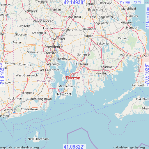
Tiverton GPS coordinates[2]
41° 37' 33.384" North, 71° 12' 48.168" West
| Map corner | latitude | longitude |
|---|---|---|
| Upper-left | 42.14938°, | -71.91651° |
| Center: | 41.62594°, | -71.21338° |
| Lower-right: | 41.09822°, | -70.51026° |
| Map W x H: | 116.9×116.9 km | = 72.6×72.6mi |
| max Lat: | 71.29058° ⇑27.9% North |
| Tiverton: | 41.62594° |
| min Lat: | ⇓72.1% South 19.06759° |
| min Long | Tiverton | max Long |
| -171.73463° | -71.21338° | -66.98998° |
| W 97.2%⇐ | ⇒2.8% E |
Elevation
Elevation of Tiverton is -16 m = -52 ft, and this is 310.8 m = 1020 ft below average elevation for this country.
| Max E: |
3189 m = 10463 ft | 99.9% |
| Avg. | 294.8 m = 967 ft | |
| Tiverton | -16 m = -52 ft | |
Min E: |
-60 m = -197 ft | 0.1% |
See also: United States elevation on elevation.city.
Geographical zone
Tiverton is located in North temperate zone (between Tropic of Cancer and the Arctic Circle). Distance of this Northern Tropic circle is 2022.5 km =1256.7 mi to South.| Distance of | km | miles | from Tiverton |
|---|---|---|---|
| North Pole | 5378.7 | 3342.2 | to North |
| Arctic Circle | 2772.8 | 1722.9 | to North |
| Tropic Cancer | 2022.5 | 1256.7 | to South |
| Equator | 4628.4 | 2876 | to South |


Nearby cities:
15 places around Tiverton: (largest is in red/bold)
• Barrington
15 km =9.3 mi,  328°
328°
• Bristol
7.2 km =4.5 mi,  322°
322°
• Fall River
9.7 km =6 mi,  29°
29°
• Head of Westport
12.6 km =7.8 mi,  92°
92°
• Melville
7.3 km =4.5 mi,  233°
233°
• Middletown
11 km =6.8 mi,  216°
216°
• Newport
17.2 km =10.7 mi,  208°
208°
• Newport East
13.7 km =8.5 mi, 206°
• North Westport
11.1 km =6.9 mi,  69°
69°
• Ocean Grove
11.5 km =7.1 mi,  1°
1°
• Portsmouth
4 km =2.5 mi, 229°
• Smith Mills
18.5 km =11.5 mi, 85°
• Somerset
17.4 km =10.8 mi,  23°
23°
• Swansea
13.7 km =8.5 mi,  8°
8°
• Warren
13 km =8.1 mi, 333°
Sources, notices
• [Note1] Compared only with cities in United States existing in our database
• [Src1] Map data: © OpenStreetMap contributors (CC-BY-SA)
• [Src2] Other city data from geonames.org with taken over terms of usage.
• [Src3] Geographical zone / Annual Mean Temperature by Robert A. Rohde @ Wikipedia
