North Westport geodata
North Westport (Massachusetts) is a populated place; located in United States in America/New_York (GMT-4) time zone. With population of 4,571 people, there are 7573 cities with bigger population in this country. Compared to other cities in United States, 72.5% of cities are located further ↓South; 97.4% of cities are located further ←West and 88.6% of cities have higher elevation than North Westport. Note1
Administrative division(s):
- Level 1: Massachusetts
- Level 2: Bristol County
- Level 3: Town of Westport


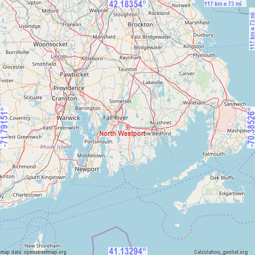
North Westport GPS coordinates[2]
41° 39' 37.368" North, 71° 5' 18.168" West
| Map corner | latitude | longitude |
|---|---|---|
| Upper-left | 42.18354°, | -71.79151° |
| Center: | 41.66038°, | -71.08838° |
| Lower-right: | 41.13294°, | -70.38526° |
| Map W x H: | 116.8×116.8 km | = 72.6×72.6mi |
| max Lat: | 71.29058° ⇑27.5% North |
| North Westport: | 41.66038° |
| min Lat: | ⇓72.5% South 19.06759° |
| min Long | North Westport | max Long |
| -171.73463° | -71.08838° | -66.98998° |
| W 97.4%⇐ | ⇒2.6% E |
Elevation
Elevation of North Westport is 19 m = 62 ft, and this is 275.8 m = 905 ft below average elevation for this country.
| Max E: |
3189 m = 10463 ft | 88.6% |
| Avg. | 294.8 m = 967 ft | |
| North Westport | 19 m = 62 ft | |
Min E: |
-60 m = -197 ft | 11.4% |
See also: United States elevation on elevation.city.
Geographical zone
North Westport is located in North temperate zone (between Tropic of Cancer and the Arctic Circle). Distance of this Northern Tropic circle is 2026.3 km =1259.1 mi to South.| Distance of | km | miles | from North Westport |
|---|---|---|---|
| North Pole | 5374.9 | 3339.8 | to North |
| Arctic Circle | 2769 | 1720.6 | to North |
| Tropic Cancer | 2026.3 | 1259.1 | to South |
| Equator | 4632.2 | 2878.3 | to South |


Nearby cities:
15 places around North Westport: (largest is in red/bold)
• Acushnet
15.2 km =9.4 mi,  81°
81°
• Acushnet Center
15.4 km =9.6 mi, 79°
• Assonet
15.2 km =9.4 mi,  6°
6°
• Bliss Corner
13.6 km =8.5 mi,  113°
113°
• Bristol
14.9 km =9.3 mi,  277°
277°
• Fall River
7.2 km =4.5 mi,  309°
309°
• Freetown
12.7 km =7.9 mi,  21°
21°
• Head of Westport
4.9 km =3 mi,  153°
153°
• New Bedford
13.7 km =8.5 mi,  101°
101°
• Ocean Grove
12.6 km =7.8 mi, 307°
• Portsmouth
14.9 km =9.3 mi,  244°
244°
• Smith Mills
8.4 km =5.2 mi, 106°
• Somerset
12.6 km =7.8 mi,  344°
344°
• Swansea
12.9 km =8 mi,  319°
319°
• Tiverton
11.1 km =6.9 mi,  249°
249°
Sources, notices
• [Note1] Compared only with cities in United States existing in our database
• [Src1] Map data: © OpenStreetMap contributors (CC-BY-SA)
• [Src2] Other city data from geonames.org with taken over terms of usage.
• [Src3] Geographical zone / Annual Mean Temperature by Robert A. Rohde @ Wikipedia
