Somerset geodata
Somerset (Massachusetts) is a populated place; located in United States in America/New_York (GMT-4) time zone. With population of 18,165 people, there are 2761 cities with bigger population in this country. Compared to other cities in United States, 73.6% of cities are located further ↓South; 97.4% of cities are located further ←West and 99.9% of cities have higher elevation than Somerset. Note1
Administrative division(s):
- Level 1: Massachusetts
- Level 2: Bristol County
- Level 3: Town of Somerset


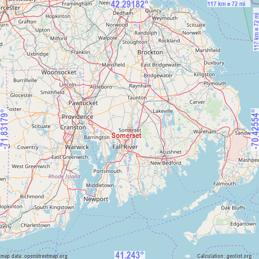
Somerset GPS coordinates[2]
41° 46' 10.38" North, 71° 7' 43.176" West
| Map corner | latitude | longitude |
|---|---|---|
| Upper-left | 42.29182°, | -71.83179° |
| Center: | 41.76955°, | -71.12866° |
| Lower-right: | 41.243°, | -70.42554° |
| Map W x H: | 116.6×116.6 km | = 72.5×72.5mi |
| max Lat: | 71.29058° ⇑26.4% North |
| Somerset: | 41.76955° |
| min Lat: | ⇓73.6% South 19.06759° |
| min Long | Somerset | max Long |
| -171.73463° | -71.12866° | -66.98998° |
| W 97.4%⇐ | ⇒2.6% E |
Elevation
Elevation of Somerset is -9 m = -30 ft, and this is 303.8 m = 997 ft below average elevation for this country.
| Max E: |
3189 m = 10463 ft | 99.9% |
| Avg. | 294.8 m = 967 ft | |
| Somerset | -9 m = -30 ft | |
Min E: |
-60 m = -197 ft | 0.1% |
See also: United States elevation on elevation.city.
Geographical zone
Somerset is located in North temperate zone (between Tropic of Cancer and the Arctic Circle). Distance of this Northern Tropic circle is 2038.4 km =1266.6 mi to South.| Distance of | km | miles | from Somerset |
|---|---|---|---|
| North Pole | 5362.7 | 3332.2 | to North |
| Arctic Circle | 2756.8 | 1713 | to North |
| Tropic Cancer | 2038.4 | 1266.6 | to South |
| Equator | 4644.3 | 2885.8 | to South |


Nearby cities:
15 places around Somerset: (largest is in red/bold)
• Assonet
5.8 km =3.6 mi,  59°
59°
• Barrington
15.3 km =9.5 mi,  257°
257°
• Berkley
9.3 km =5.8 mi,  24°
24°
• Bristol
15.4 km =9.6 mi,  227°
227°
• Dighton
5 km =3.1 mi,  7°
7°
• Fall River
7.9 km =4.9 mi,  196°
196°
• Freetown
8 km =5 mi,  92°
92°
• Head of Westport
17.4 km =10.8 mi,  161°
161°
• North Westport
12.6 km =7.8 mi, 164°
• Ocean Grove
8 km =5 mi,  236°
236°
• Rehoboth
12.7 km =7.9 mi,  308°
308°
• Swansea
5.6 km =3.5 mi, 244°
• Taunton
14.9 km =9.3 mi, 12°
• Tiverton
17.4 km =10.8 mi, 203°
• Warren
13.5 km =8.4 mi,  251°
251°
Sources, notices
• [Note1] Compared only with cities in United States existing in our database
• [Src1] Map data: © OpenStreetMap contributors (CC-BY-SA)
• [Src2] Other city data from geonames.org with taken over terms of usage.
• [Src3] Geographical zone / Annual Mean Temperature by Robert A. Rohde @ Wikipedia
