Warwick geodata
Warwick (Rhode Island) is a populated place; located in United States in America/New_York (GMT-4) time zone. With population of 81,699 people, there are 479 cities with bigger population in this country. Compared to other cities in United States, 72.9% of cities are located further ↓South; 96.8% of cities are located further ←West and 99.9% of cities have higher elevation than Warwick. Note1


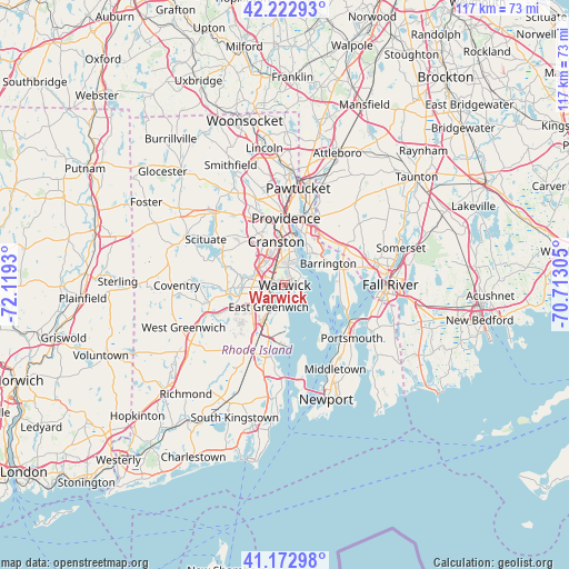
Warwick GPS coordinates[2]
41° 42' 0.36" North, 71° 24' 58.212" West
| Map corner | latitude | longitude |
|---|---|---|
| Upper-left | 42.22293°, | -72.1193° |
| Center: | 41.7001°, | -71.41617° |
| Lower-right: | 41.17298°, | -70.71305° |
| Map W x H: | 116.7×116.7 km | = 72.5×72.5mi |
| max Lat: | 71.29058° ⇑27.1% North |
| Warwick: | 41.7001° |
| min Lat: | ⇓72.9% South 19.06759° |
| min Long | Warwick | max Long |
| -171.73463° | -71.41617° | -66.98998° |
| W 96.8%⇐ | ⇒3.2% E |
Elevation
Elevation of Warwick is -9 m = -30 ft, and this is 303.8 m = 997 ft below average elevation for this country.
| Max E: |
3189 m = 10463 ft | 99.9% |
| Avg. | 294.8 m = 967 ft | |
| Warwick | -9 m = -30 ft | |
Min E: |
-60 m = -197 ft | 0.1% |
See also: Warwick elevation on elevation.city.
Geographical zone
Warwick is located in North temperate zone (between Tropic of Cancer and the Arctic Circle). Distance of this Northern Tropic circle is 2030.7 km =1261.8 mi to South.| Distance of | km | miles | from Warwick |
|---|---|---|---|
| North Pole | 5370.4 | 3337 | to North |
| Arctic Circle | 2764.6 | 1717.8 | to North |
| Tropic Cancer | 2030.7 | 1261.8 | to South |
| Equator | 4636.6 | 2881 | to South |


Nearby cities:
15 places around Warwick: (largest is in red/bold)
• Barrington
10 km =6.2 mi,  63°
63°
• Bristol
12.7 km =7.9 mi,  101°
101°
• Cranston
9 km =5.6 mi,  348°
348°
• East Greenwich
5.5 km =3.4 mi,  216°
216°
• East Providence
13.2 km =8.2 mi,  16°
16°
• Exeter
16.9 km =10.5 mi, 216°
• Johnston
15.5 km =9.6 mi,  330°
330°
• Melville
16.7 km =10.4 mi,  138°
138°
• North Kingstown
17.2 km =10.7 mi,  193°
193°
• North Providence
17.2 km =10.7 mi, 346°
• Ocean Grove
17.5 km =10.9 mi,  79°
79°
• Providence
13.8 km =8.6 mi,  1°
1°
• Seekonk
13.7 km =8.5 mi,  28°
28°
• Warren
11.6 km =7.2 mi,  73°
73°
• West Warwick
8.8 km =5.5 mi,  267°
267°
Sources, notices
• [Note1] Compared only with cities in United States existing in our database
• [Src1] Map data: © OpenStreetMap contributors (CC-BY-SA)
• [Src2] Other city data from geonames.org with taken over terms of usage.
• [Src3] Geographical zone / Annual Mean Temperature by Robert A. Rohde @ Wikipedia
