Cranston geodata
Cranston (Rhode Island) is a seat of a third-order administrative division; located in United States in America/New_York (GMT-4) time zone. With population of 81,073 people, there are 485 cities with bigger population in this country. Compared to other cities in United States, 73.7% of cities are located further ↓South; 96.8% of cities are located further ←West and 99.8% of cities have higher elevation than Cranston. Note1
Administrative division(s):
- Level 1: Rhode Island
- Level 2: Providence County
- Level 3: City of Cranston


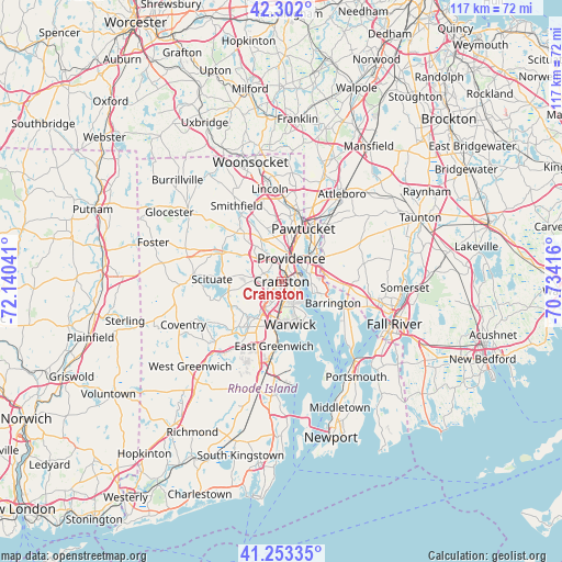
Cranston GPS coordinates[2]
41° 46' 47.352" North, 71° 26' 14.208" West
| Map corner | latitude | longitude |
|---|---|---|
| Upper-left | 42.302°, | -72.14041° |
| Center: | 41.77982°, | -71.43728° |
| Lower-right: | 41.25335°, | -70.73416° |
| Map W x H: | 116.6×116.6 km | = 72.5×72.5mi |
| max Lat: | 71.29058° ⇑26.3% North |
| Cranston: | 41.77982° |
| min Lat: | ⇓73.7% South 19.06759° |
| min Long | Cranston | max Long |
| -171.73463° | -71.43728° | -66.98998° |
| W 96.8%⇐ | ⇒3.2% E |
Elevation
Elevation of Cranston is -1 m = -3 ft, and this is 295.8 m = 970 ft below average elevation for this country.
| Max E: |
3189 m = 10463 ft | 99.8% |
| Avg. | 294.8 m = 967 ft | |
| Cranston | -1 m = -3 ft | |
Min E: |
-60 m = -197 ft | 0.2% |
See also: Cranston elevation on elevation.city.
Geographical zone
Cranston is located in North temperate zone (between Tropic of Cancer and the Arctic Circle). Distance of this Northern Tropic circle is 2039.6 km =1267.3 mi to South.| Distance of | km | miles | from Cranston |
|---|---|---|---|
| North Pole | 5361.6 | 3331.5 | to North |
| Arctic Circle | 2755.7 | 1712.3 | to North |
| Tropic Cancer | 2039.6 | 1267.3 | to South |
| Equator | 4645.5 | 2886.6 | to South |


Nearby cities:
15 places around Cranston: (largest is in red/bold)
• Barrington
11.5 km =7.1 mi,  112°
112°
• Central Falls
12.9 km =8 mi,  16°
16°
• East Greenwich
13.4 km =8.3 mi,  186°
186°
• East Providence
6.7 km =4.2 mi,  55°
55°
• Greenville
13.9 km =8.6 mi,  316°
316°
• Johnston
7.4 km =4.6 mi,  309°
309°
• North Providence
8.2 km =5.1 mi,  342°
342°
• North Scituate
13.7 km =8.5 mi,  294°
294°
• Pawtucket
11.9 km =7.4 mi, 22°
• Providence
5.3 km =3.3 mi, 22°
• Seekonk
8.9 km =5.5 mi,  69°
69°
• Valley Falls
14.6 km =9.1 mi, 15°
• Warren
14 km =8.7 mi, 113°
• Warwick
9 km =5.6 mi,  168°
168°
• West Warwick
11.6 km =7.2 mi,  217°
217°
Sources, notices
• [Note1] Compared only with cities in United States existing in our database
• [Src1] Map data: © OpenStreetMap contributors (CC-BY-SA)
• [Src2] Other city data from geonames.org with taken over terms of usage.
• [Src3] Geographical zone / Annual Mean Temperature by Robert A. Rohde @ Wikipedia
