Providence geodata
Providence (Rhode Island) is a seat of a first-order administrative division; located in United States in America/New_York (GMT-4) time zone. With population of 179,207 people, there are 148 cities with bigger population in this country. Compared to other cities in United States, 74.1% of cities are located further ↓South; 96.8% of cities are located further ←West and 99.9% of cities have higher elevation than Providence. Note1
Administrative division(s):
- Level 1: Rhode Island
- Level 2: Providence County
- Level 3: City of Providence


Providence GPS coordinates[2]
41° 49' 26.364" North, 71° 24' 46.188" West
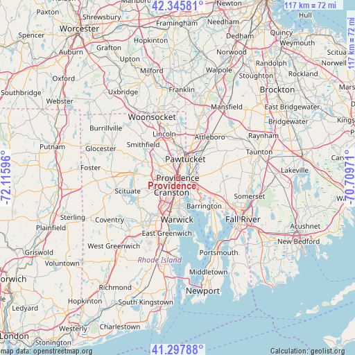
| Map corner | latitude | longitude |
|---|---|---|
| Upper-left | 42.34581°, | -72.11596° |
| Center: | 41.82399°, | -71.41283° |
| Lower-right: | 41.29788°, | -70.70971° |
| Map W x H: | 116.5×116.5 km | = 72.4×72.4mi |
| max Lat: | 71.29058° ⇑25.9% North |
| Providence: | 41.82399° |
| min Lat: | ⇓74.1% South 19.06759° |
| min Long | Providence | max Long |
| -171.73463° | -71.41283° | -66.98998° |
| W 96.8%⇐ | ⇒3.2% E |
Elevation
Elevation of Providence is -17 m = -56 ft, and this is 311.8 m = 1023 ft below average elevation for this country.
| Max E: |
3189 m = 10463 ft | 99.9% |
| Avg. | 294.8 m = 967 ft | |
| Providence | -17 m = -56 ft | |
Min E: |
-60 m = -197 ft | 0.1% |
See also: Providence elevation on elevation.city.
Geographical zone
Providence is located in North temperate zone (between Tropic of Cancer and the Arctic Circle). Distance of this Northern Tropic circle is 2044.5 km =1270.4 mi to South.| Distance of | km | miles | from Providence |
|---|---|---|---|
| North Pole | 5356.7 | 3328.5 | to North |
| Arctic Circle | 2750.8 | 1709.3 | to North |
| Tropic Cancer | 2044.5 | 1270.4 | to South |
| Equator | 4650.4 | 2889.6 | to South |


Nearby cities:
15 places around Providence: (largest is in red/bold)
• Barrington
12.7 km =7.9 mi,  137°
137°
• Central Falls
7.6 km =4.7 mi,  12°
12°
• Cranston
5.3 km =3.3 mi,  202°
202°
• East Providence
3.7 km =2.3 mi,  107°
107°
• Greenville
12.7 km =7.9 mi,  294°
294°
• Johnston
7.8 km =4.8 mi,  268°
268°
• Lincoln
11 km =6.8 mi,  350°
350°
• North Providence
5.3 km =3.3 mi,  303°
303°
• North Scituate
14.5 km =9 mi, 273°
• North Seekonk
10 km =6.2 mi,  43°
43°
• Pawtucket
6.6 km =4.1 mi,  22°
22°
• Rehoboth
13.7 km =8.5 mi,  82°
82°
• Seekonk
6.5 km =4 mi, 105°
• Valley Falls
9.4 km =5.8 mi, 11°
• Warwick
13.8 km =8.6 mi,  181°
181°
Sources, notices
• [Note1] Compared only with cities in United States existing in our database
• [Src1] Map data: © OpenStreetMap contributors (CC-BY-SA)
• [Src2] Other city data from geonames.org with taken over terms of usage.
• [Src3] Geographical zone / Annual Mean Temperature by Robert A. Rohde @ Wikipedia
