White River geodata
White River (South Dakota) is a seat of a second-order administrative division; located in United States in America/Chicago (GMT-5) time zone. With population of 575 people, there are 19968 cities with bigger population in this country. Compared to other cities in United States, 86.6% of cities are located further ↓South; 81.2% of cities are located further →East and 90.3% of cities have lower elevation than White River. Note1
Administrative division(s):
- Level 1: South Dakota
- Level 2: Mellette County
- Level 3: City of White River


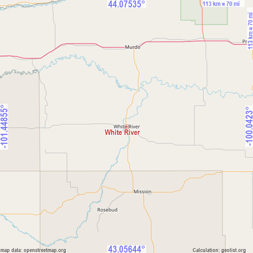
White River GPS coordinates[2]
43° 34' 4.98" North, 100° 44' 43.512" West
| Map corner | latitude | longitude |
|---|---|---|
| Upper-left | 44.07535°, | -101.44855° |
| Center: | 43.56805°, | -100.74542° |
| Lower-right: | 43.05644°, | -100.0423° |
| Map W x H: | 113.3×113.3 km | = 70.4×70.4mi |
| max Lat: | 71.29058° ⇑13.4% North |
| White River: | 43.56805° |
| min Lat: | ⇓86.6% South 19.06759° |
| min Long | White River | max Long |
| -171.73463° | -100.74542° | -66.98998° |
| W 18.8%⇐ | ⇒81.2% E |
Elevation
Elevation of White River is 651 m = 2136 ft, and this is 356.2 m = 1169 ft above average elevation for this country.
| Max E: |
3189 m = 10463 ft | 9.7% |
| White River | 651 m 2136 ft | |
| Avg. | 294.8 m = 967 ft | |
Min E: |
-60 m = -197 ft | 90.3% |
See also: United States elevation on elevation.city.
Geographical zone
White River is located in North temperate zone (between Tropic of Cancer and the Arctic Circle). Distance of this Northern Tropic circle is 2238.4 km =1390.9 mi to South.| Distance of | km | miles | from White River |
|---|---|---|---|
| North Pole | 5162.7 | 3208 | to North |
| Arctic Circle | 2556.9 | 1588.8 | to North |
| Tropic Cancer | 2238.4 | 1390.9 | to South |
| Equator | 4844.3 | 3010.1 | to South |


Nearby cities:
15 places around White River: (largest is in red/bold)
• Antelope
30.9 km =19.2 mi,  162°
162°
• Fort Pierre
92.3 km =57.4 mi,  18°
18°
• Kadoka
68.2 km =42.4 mi,  295°
295°
• Kennebec
80.2 km =49.8 mi,  62°
62°
• Martin
91.1 km =56.6 mi,  241°
241°
• Mission
30 km =18.6 mi,  166°
166°
• Murdo
35.7 km =22.2 mi,  4°
4°
• Parmelee
35.5 km =22.1 mi,  219°
219°
• Philip
90.5 km =56.2 mi,  305°
305°
• Presho
67 km =41.6 mi, 55°
• Rosebud
38.3 km =23.8 mi,  193°
193°
• Saint Francis
48.8 km =30.3 mi,  195°
195°
• Valentine
78.9 km =49 mi, 168°
• Wanblee
73.7 km =45.8 mi,  270°
270°
• Winner
74.6 km =46.4 mi,  106°
106°
Sources, notices
• [Note1] Compared only with cities in United States existing in our database
• [Src1] Map data: © OpenStreetMap contributors (CC-BY-SA)
• [Src2] Other city data from geonames.org with taken over terms of usage.
• [Src3] Geographical zone / Annual Mean Temperature by Robert A. Rohde @ Wikipedia
