Ashwaubenon geodata
Ashwaubenon (Wisconsin) is a populated place; located in United States in America/Chicago (GMT-5) time zone. With population of 17,176 people, there are 2883 cities with bigger population in this country. Compared to other cities in United States, 90.4% of cities are located further ↓South; 53.2% of cities are located further →East and 53.6% of cities have higher elevation than Ashwaubenon. Note1
Administrative division(s):
- Level 1: Wisconsin
- Level 2: Brown County
- Level 3: Village of Ashwaubenon


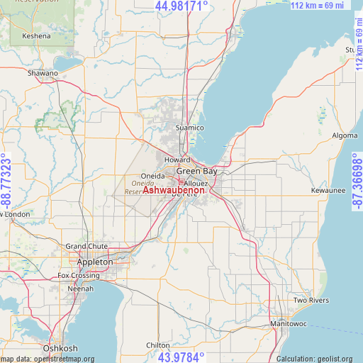
Ashwaubenon GPS coordinates[2]
44° 28' 55.956" North, 88° 4' 12.36" West
| Map corner | latitude | longitude |
|---|---|---|
| Upper-left | 44.98171°, | -88.77323° |
| Center: | 44.48221°, | -88.0701° |
| Lower-right: | 43.9784°, | -87.36698° |
| Map W x H: | 111.6×111.6 km | = 69.3×69.3mi |
| max Lat: | 71.29058° ⇑9.6% North |
| Ashwaubenon: | 44.48221° |
| min Lat: | ⇓90.4% South 19.06759° |
| min Long | Ashwaubenon | max Long |
| -171.73463° | -88.0701° | -66.98998° |
| W 46.8%⇐ | ⇒53.2% E |
Elevation
Elevation of Ashwaubenon is 185 m = 607 ft, and this is 109.8 m = 360 ft below average elevation for this country.
| Max E: |
3189 m = 10463 ft | 53.6% |
| Avg. | 294.8 m = 967 ft | |
| Ashwaubenon | 185 m = 607 ft | |
Min E: |
-60 m = -197 ft | 46.4% |
See also: United States elevation on elevation.city.
Geographical zone
Ashwaubenon is located in North temperate zone (between Tropic of Cancer and the Arctic Circle). Distance of this Northern Tropic circle is 2340 km =1454 mi to South.| Distance of | km | miles | from Ashwaubenon |
|---|---|---|---|
| North Pole | 5061.1 | 3144.8 | to North |
| Arctic Circle | 2455.2 | 1525.6 | to North |
| Tropic Cancer | 2340 | 1454 | to South |
| Equator | 4946 | 3073.3 | to South |


Nearby cities:
15 places around Ashwaubenon: (largest is in red/bold)
• Allouez
4.3 km =2.7 mi,  96°
96°
• Bellevue
12.6 km =7.8 mi,  109°
109°
• De Pere
3.8 km =2.4 mi,  168°
168°
• Denmark
24.4 km =15.2 mi,  127°
127°
• Glenmore
15.6 km =9.7 mi, 133°
• Green Bay
5.7 km =3.5 mi,  44°
44°
• Greenleaf
18.9 km =11.7 mi,  186°
186°
• Hobart
6.6 km =4.1 mi,  286°
286°
• Howard
7 km =4.3 mi,  348°
348°
• Oneida
9.1 km =5.7 mi,  281°
281°
• Pittsfield
19 km =11.8 mi,  313°
313°
• Pulaski
25.2 km =15.7 mi,  327°
327°
• Seymour
21 km =13 mi, 280°
• Suamico
16.8 km =10.4 mi,  8°
8°
• Wrightstown
18.9 km =11.7 mi,  202°
202°
Sources, notices
• [Note1] Compared only with cities in United States existing in our database
• [Src1] Map data: © OpenStreetMap contributors (CC-BY-SA)
• [Src2] Other city data from geonames.org with taken over terms of usage.
• [Src3] Geographical zone / Annual Mean Temperature by Robert A. Rohde @ Wikipedia
