Birnamwood geodata
Birnamwood (Wisconsin) is a populated place; located in United States in America/Chicago (GMT-5) time zone. With population of 798 people, there are 17827 cities with bigger population in this country. Compared to other cities in United States, 92.3% of cities are located further ↓South; 56.8% of cities are located further →East and 83.6% of cities have lower elevation than Birnamwood. Note1
Administrative division(s):
- Level 1: Wisconsin
- Level 2: Shawano County
- Level 3: Village of Birnamwood


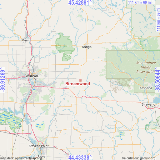
Birnamwood GPS coordinates[2]
44° 55' 59.88" North, 89° 12' 34.416" West
| Map corner | latitude | longitude |
|---|---|---|
| Upper-left | 45.42891°, | -89.91269° |
| Center: | 44.9333°, | -89.20956° |
| Lower-right: | 44.43338°, | -88.50644° |
| Map W x H: | 110.7×110.7 km | = 68.8×68.8mi |
| max Lat: | 71.29058° ⇑7.7% North |
| Birnamwood: | 44.9333° |
| min Lat: | ⇓92.3% South 19.06759° |
| min Long | Birnamwood | max Long |
| -171.73463° | -89.20956° | -66.98998° |
| W 43.2%⇐ | ⇒56.8% E |
Elevation
Elevation of Birnamwood is 398 m = 1306 ft, and this is 103.2 m = 339 ft above average elevation for this country.
| Max E: |
3189 m = 10463 ft | 16.4% |
| Birnamwood | 398 m 1306 ft | |
| Avg. | 294.8 m = 967 ft | |
Min E: |
-60 m = -197 ft | 83.6% |
See also: United States elevation on elevation.city.
Geographical zone
Birnamwood is located in North temperate zone (between Tropic of Cancer and the Arctic Circle). Distance of this Northern Tropic circle is 2390.2 km =1485.2 mi to South.| Distance of | km | miles | from Birnamwood |
|---|---|---|---|
| North Pole | 5010.9 | 3113.6 | to North |
| Arctic Circle | 2405.1 | 1494.5 | to North |
| Tropic Cancer | 2390.2 | 1485.2 | to South |
| Equator | 4996.1 | 3104.4 | to South |


Nearby cities:
15 places around Birnamwood: (largest is in red/bold)
• Antigo
23.4 km =14.5 mi,  11°
11°
• Bevent
23 km =14.3 mi,  218°
218°
• Evergreen
35.2 km =21.9 mi,  253°
253°
• Gresham
34.4 km =21.4 mi,  105°
105°
• Hatley
11.4 km =7.1 mi,  243°
243°
• Kronenwetter
32.5 km =20.2 mi, 247°
• Marion
38.6 km =24 mi,  139°
139°
• Neopit
30.3 km =18.8 mi,  79°
79°
• Rib Mountain
36.7 km =22.8 mi,  266°
266°
• Rothschild
32.7 km =20.3 mi,  260°
260°
• Schofield
31.2 km =19.4 mi, 265°
• Tigerton
24.3 km =15.1 mi,  151°
151°
• Wausau
33.2 km =20.6 mi, 274°
• Weston
27 km =16.8 mi, 259°
• Wittenberg
12.2 km =7.6 mi,  165°
165°
Sources, notices
• [Note1] Compared only with cities in United States existing in our database
• [Src1] Map data: © OpenStreetMap contributors (CC-BY-SA)
• [Src2] Other city data from geonames.org with taken over terms of usage.
• [Src3] Geographical zone / Annual Mean Temperature by Robert A. Rohde @ Wikipedia
