Wausau geodata
Wausau (Wisconsin) is a seat of a second-order administrative division; located in United States in America/Chicago (GMT-5) time zone. With population of 39,094 people, there are 1244 cities with bigger population in this country. Compared to other cities in United States, 92.4% of cities are located further ↓South; 57.9% of cities are located further →East and 81.6% of cities have lower elevation than Wausau. Note1


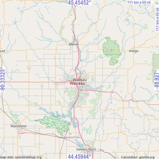
Wausau GPS coordinates[2]
44° 57' 32.904" North, 89° 37' 48.432" West
| Map corner | latitude | longitude |
|---|---|---|
| Upper-left | 45.45452°, | -90.33325° |
| Center: | 44.95914°, | -89.63012° |
| Lower-right: | 44.45944°, | -88.927° |
| Map W x H: | 110.6×110.6 km | = 68.7×68.7mi |
| max Lat: | 71.29058° ⇑7.6% North |
| Wausau: | 44.95914° |
| min Lat: | ⇓92.4% South 19.06759° |
| min Long | Wausau | max Long |
| -171.73463° | -89.63012° | -66.98998° |
| W 42.1%⇐ | ⇒57.9% E |
Elevation
Elevation of Wausau is 371 m = 1217 ft, and this is 76.2 m = 250 ft above average elevation for this country.
| Max E: |
3189 m = 10463 ft | 18.4% |
| Wausau | 371 m 1217 ft | |
| Avg. | 294.8 m = 967 ft | |
Min E: |
-60 m = -197 ft | 81.6% |
See also: United States elevation on elevation.city.
Geographical zone
Wausau is located in North temperate zone (between Tropic of Cancer and the Arctic Circle). Distance of this Northern Tropic circle is 2393.1 km =1487 mi to South.| Distance of | km | miles | from Wausau |
|---|---|---|---|
| North Pole | 5008.1 | 3111.9 | to North |
| Arctic Circle | 2402.2 | 1492.7 | to North |
| Tropic Cancer | 2393.1 | 1487 | to South |
| Equator | 4999 | 3106.2 | to South |


Nearby cities:
15 places around Wausau: (largest is in red/bold)
• Athens
35.9 km =22.3 mi,  283°
283°
• Bevent
28.3 km =17.6 mi,  137°
137°
• Birnamwood
33.2 km =20.6 mi,  94°
94°
• Edgar
26.5 km =16.5 mi,  262°
262°
• Evergreen
13 km =8.1 mi,  182°
182°
• Hatley
24.3 km =15.1 mi,  109°
109°
• Kronenwetter
15.5 km =9.6 mi,  168°
168°
• Maine
8.9 km =5.5 mi,  327°
327°
• Marathon
16.9 km =10.5 mi, 258°
• Merrill
25 km =15.5 mi,  350°
350°
• Mosinee
19.3 km =12 mi,  197°
197°
• Rib Mountain
6.3 km =3.9 mi,  214°
214°
• Rothschild
8 km =5 mi, 174°
• Schofield
5.9 km =3.7 mi,  159°
159°
• Weston
10 km =6.2 mi, 139°
Sources, notices
• [Note1] Compared only with cities in United States existing in our database
• [Src1] Map data: © OpenStreetMap contributors (CC-BY-SA)
• [Src2] Other city data from geonames.org with taken over terms of usage.
• [Src3] Geographical zone / Annual Mean Temperature by Robert A. Rohde @ Wikipedia
