Cassville geodata
Cassville (Wisconsin) is a populated place; located in United States in America/Chicago (GMT-5) time zone. With population of 924 people, there are 16842 cities with bigger population in this country. Compared to other cities in United States, 81.4% of cities are located further ↓South; 62% of cities are located further →East and 51.6% of cities have higher elevation than Cassville. Note1


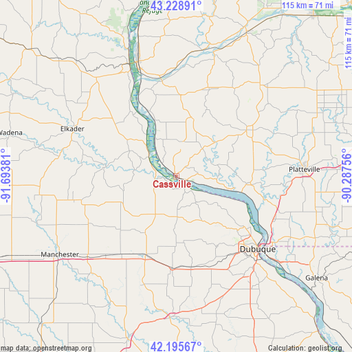
Cassville GPS coordinates[2]
42° 42' 51.984" North, 90° 59' 26.448" West
| Map corner | latitude | longitude |
|---|---|---|
| Upper-left | 43.22891°, | -91.69381° |
| Center: | 42.71444°, | -90.99068° |
| Lower-right: | 42.19567°, | -90.28756° |
| Map W x H: | 114.9×114.9 km | = 71.4×71.4mi |
| max Lat: | 71.29058° ⇑18.6% North |
| Cassville: | 42.71444° |
| min Lat: | ⇓81.4% South 19.06759° |
| min Long | Cassville | max Long |
| -171.73463° | -90.99068° | -66.98998° |
| W 38%⇐ | ⇒62% E |
Elevation
Elevation of Cassville is 192 m = 630 ft, and this is 102.8 m = 337 ft below average elevation for this country.
| Max E: |
3189 m = 10463 ft | 51.6% |
| Avg. | 294.8 m = 967 ft | |
| Cassville | 192 m = 630 ft | |
Min E: |
-60 m = -197 ft | 48.4% |
See also: United States elevation on elevation.city.
Geographical zone
Cassville is located in North temperate zone (between Tropic of Cancer and the Arctic Circle). Distance of this Northern Tropic circle is 2143.5 km =1331.9 mi to South.| Distance of | km | miles | from Cassville |
|---|---|---|---|
| North Pole | 5257.7 | 3267 | to North |
| Arctic Circle | 2651.8 | 1647.8 | to North |
| Tropic Cancer | 2143.5 | 1331.9 | to South |
| Equator | 4749.4 | 2951.1 | to South |


Nearby cities:
15 places around Cassville: (largest is in red/bold)
• Asbury
29.6 km =18.4 mi,  138°
138°
• Bloomington
19.8 km =12.3 mi,  16°
16°
• Dickeyville
34 km =21.1 mi,  106°
106°
• Dubuque
35.7 km =22.2 mi,  131°
131°
• Dyersville
27.8 km =17.3 mi,  202°
202°
• Earlville
34.7 km =21.6 mi,  221°
221°
• Edgewood
34.5 km =21.4 mi,  256°
256°
• Elkader
37.2 km =23.1 mi,  294°
294°
• Epworth
30.3 km =18.8 mi,  170°
170°
• Farley
30.2 km =18.8 mi,  182°
182°
• Garnavillo
26.4 km =16.4 mi,  310°
310°
• Guttenberg
11.9 km =7.4 mi, 311°
• Lancaster
27.2 km =16.9 mi,  57°
57°
• Peosta
31.5 km =19.6 mi,  158°
158°
• Potosi
22.9 km =14.2 mi,  96°
96°
Sources, notices
• [Note1] Compared only with cities in United States existing in our database
• [Src1] Map data: © OpenStreetMap contributors (CC-BY-SA)
• [Src2] Other city data from geonames.org with taken over terms of usage.
• [Src3] Geographical zone / Annual Mean Temperature by Robert A. Rohde @ Wikipedia
