Peosta geodata
Peosta (Iowa) is a populated place; located in United States in America/Chicago (GMT-5) time zone. With population of 1,618 people, there are 13231 cities with bigger population in this country. Compared to other cities in United States, 79.3% of cities are located further ↓South; 61.8% of cities are located further →East and 76.2% of cities have lower elevation than Peosta. Note1


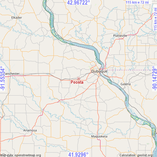
Peosta GPS coordinates[2]
42° 27' 2.016" North, 90° 51' 1.476" West
| Map corner | latitude | longitude |
|---|---|---|
| Upper-left | 42.96722°, | -91.55354° |
| Center: | 42.45056°, | -90.85041° |
| Lower-right: | 41.9296°, | -90.14729° |
| Map W x H: | 115.4×115.4 km | = 71.7×71.7mi |
| max Lat: | 71.29058° ⇑20.7% North |
| Peosta: | 42.45056° |
| min Lat: | ⇓79.3% South 19.06759° |
| min Long | Peosta | max Long |
| -171.73463° | -90.85041° | -66.98998° |
| W 38.2%⇐ | ⇒61.8% E |
Elevation
Elevation of Peosta is 321 m = 1053 ft, and this is 26.2 m = 86 ft above average elevation for this country.
| Max E: |
3189 m = 10463 ft | 23.8% |
| Peosta | 321 m 1053 ft | |
| Avg. | 294.8 m = 967 ft | |
Min E: |
-60 m = -197 ft | 76.2% |
See also: United States elevation on elevation.city.
Geographical zone
Peosta is located in North temperate zone (between Tropic of Cancer and the Arctic Circle). Distance of this Northern Tropic circle is 2114.1 km =1313.6 mi to South.| Distance of | km | miles | from Peosta |
|---|---|---|---|
| North Pole | 5287 | 3285.2 | to North |
| Arctic Circle | 2681.1 | 1666 | to North |
| Tropic Cancer | 2114.1 | 1313.6 | to South |
| Equator | 4720.1 | 2932.9 | to South |


Nearby cities:
15 places around Peosta: (largest is in red/bold)
• Asbury
10.8 km =6.7 mi,  48°
48°
• Cascade
21.6 km =13.4 mi,  218°
218°
• Cassville
31.5 km =19.6 mi,  338°
338°
• Dickeyville
28.9 km =18 mi, 47°
• Dubuque
16.2 km =10.1 mi,  69°
69°
• Dyersville
22.7 km =14.1 mi,  279°
279°
• Earlville
34.8 km =21.6 mi, 275°
• East Dubuque
17.6 km =10.9 mi, 74°
• Epworth
6.7 km =4.2 mi,  264°
264°
• Farley
12.8 km =8 mi,  266°
266°
• Galena
34.8 km =21.6 mi,  96°
96°
• Hazel Green
35.3 km =21.9 mi, 74°
• Hopkinton
34.8 km =21.6 mi,  250°
250°
• Monticello
36.4 km =22.6 mi,  229°
229°
• Potosi
28.9 km =18 mi,  23°
23°
Sources, notices
• [Note1] Compared only with cities in United States existing in our database
• [Src1] Map data: © OpenStreetMap contributors (CC-BY-SA)
• [Src2] Other city data from geonames.org with taken over terms of usage.
• [Src3] Geographical zone / Annual Mean Temperature by Robert A. Rohde @ Wikipedia
