Clayton geodata
Clayton (Wisconsin) is a populated place; located in United States in America/Chicago (GMT-5) time zone. With population of 550 people, there are 20274 cities with bigger population in this country. Compared to other cities in United States, 93.5% of cities are located further ↓South; 64.5% of cities are located further →East and 81% of cities have lower elevation than Clayton. Note1


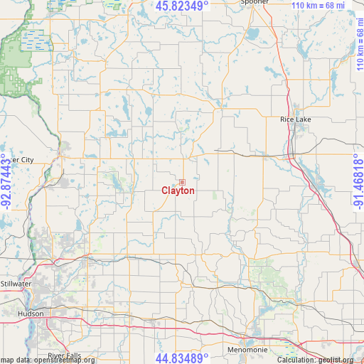
Clayton GPS coordinates[2]
45° 19' 52.86" North, 92° 10' 16.68" West
| Map corner | latitude | longitude |
|---|---|---|
| Upper-left | 45.82349°, | -92.87443° |
| Center: | 45.33135°, | -92.1713° |
| Lower-right: | 44.83489°, | -91.46818° |
| Map W x H: | 109.9×109.9 km | = 68.3×68.3mi |
| max Lat: | 71.29058° ⇑6.5% North |
| Clayton: | 45.33135° |
| min Lat: | ⇓93.5% South 19.06759° |
| min Long | Clayton | max Long |
| -171.73463° | -92.1713° | -66.98998° |
| W 35.5%⇐ | ⇒64.5% E |
Elevation
Elevation of Clayton is 365 m = 1198 ft, and this is 70.2 m = 230 ft above average elevation for this country.
| Max E: |
3189 m = 10463 ft | 19% |
| Clayton | 365 m 1198 ft | |
| Avg. | 294.8 m = 967 ft | |
Min E: |
-60 m = -197 ft | 81% |
See also: United States elevation on elevation.city.
Geographical zone
Clayton is located in North temperate zone (between Tropic of Cancer and the Arctic Circle). Distance of this North polar circle is 2360.8 km =1466.9 mi to North.| Distance of | km | miles | from Clayton |
|---|---|---|---|
| North Pole | 4966.7 | 3086.2 | to North |
| Arctic Circle | 2360.8 | 1466.9 | to North |
| Tropic Cancer | 2434.5 | 1512.7 | to South |
| Equator | 5040.4 | 3132 | to South |


Nearby cities:
15 places around Clayton: (largest is in red/bold)
• Almena
14.4 km =8.9 mi,  48°
48°
• Amery
15.2 km =9.4 mi,  259°
259°
• Balsam Lake
25.9 km =16.1 mi,  301°
301°
• Barron
26.3 km =16.3 mi,  72°
72°
• Boyceville
33.6 km =20.9 mi,  162°
162°
• Cameron
34.5 km =21.4 mi,  75°
75°
• Centuria
32.7 km =20.3 mi,  294°
294°
• Clear Lake
11.8 km =7.3 mi,  221°
221°
• Cumberland
25.3 km =15.7 mi,  27°
27°
• Dresser
36.2 km =22.5 mi,  274°
274°
• Glenwood City
30.3 km =18.8 mi,  180°
180°
• Luck
36.5 km =22.7 mi,  318°
318°
• Milltown
34.1 km =21.2 mi,  309°
309°
• Star Prairie
31.9 km =19.8 mi,  242°
242°
• Turtle Lake
7.4 km =4.6 mi,  17°
17°
Sources, notices
• [Note1] Compared only with cities in United States existing in our database
• [Src1] Map data: © OpenStreetMap contributors (CC-BY-SA)
• [Src2] Other city data from geonames.org with taken over terms of usage.
• [Src3] Geographical zone / Annual Mean Temperature by Robert A. Rohde @ Wikipedia
