Boyceville geodata
Boyceville (Wisconsin) is a populated place; located in United States in America/Chicago (GMT-5) time zone. With population of 1,103 people, there are 15658 cities with bigger population in this country. Compared to other cities in United States, 92.7% of cities are located further ↓South; 64.2% of cities are located further →East and 70.1% of cities have lower elevation than Boyceville. Note1


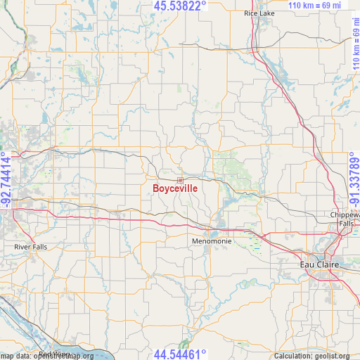
Boyceville GPS coordinates[2]
45° 2' 36.852" North, 92° 2' 27.636" West
| Map corner | latitude | longitude |
|---|---|---|
| Upper-left | 45.53822°, | -92.74414° |
| Center: | 45.04357°, | -92.04101° |
| Lower-right: | 44.54461°, | -91.33789° |
| Map W x H: | 110.5×110.5 km | = 68.7×68.7mi |
| max Lat: | 71.29058° ⇑7.3% North |
| Boyceville: | 45.04357° |
| min Lat: | ⇓92.7% South 19.06759° |
| min Long | Boyceville | max Long |
| -171.73463° | -92.04101° | -66.98998° |
| W 35.8%⇐ | ⇒64.2% E |
Elevation
Elevation of Boyceville is 286 m = 938 ft, and this is 8.8 m = 29 ft below average elevation for this country.
| Max E: |
3189 m = 10463 ft | 29.9% |
| Avg. | 294.8 m = 967 ft | |
| Boyceville | 286 m = 938 ft | |
Min E: |
-60 m = -197 ft | 70.1% |
See also: United States elevation on elevation.city.
Geographical zone
Boyceville is located in North temperate zone (between Tropic of Cancer and the Arctic Circle). Distance of this North polar circle is 2392.8 km =1486.8 mi to North.| Distance of | km | miles | from Boyceville |
|---|---|---|---|
| North Pole | 4998.7 | 3106 | to North |
| Arctic Circle | 2392.8 | 1486.8 | to North |
| Tropic Cancer | 2402.5 | 1492.8 | to South |
| Equator | 5008.4 | 3112.1 | to South |


Nearby cities:
15 places around Boyceville: (largest is in red/bold)
• Amery
38.6 km =24 mi,  319°
319°
• Baldwin
27.6 km =17.1 mi,  251°
251°
• Clayton
33.6 km =20.9 mi,  342°
342°
• Clear Lake
29.4 km =18.3 mi, 322°
• Colfax
25.2 km =15.7 mi,  101°
101°
• El Paso
38.7 km =24 mi,  218°
218°
• Elk Mound
33.4 km =20.8 mi,  124°
124°
• Elmwood
30.3 km =18.8 mi,  195°
195°
• Glenwood City
10.5 km =6.5 mi,  279°
279°
• Hammond
31.9 km =19.8 mi,  256°
256°
• Menomonie
21 km =13 mi,  152°
152°
• Spring Valley
27 km =16.8 mi, 215°
• Tainter Lake
16.4 km =10.2 mi,  111°
111°
• Turtle Lake
39.8 km =24.7 mi,  348°
348°
• Woodville
22.1 km =13.7 mi,  242°
242°
Sources, notices
• [Note1] Compared only with cities in United States existing in our database
• [Src1] Map data: © OpenStreetMap contributors (CC-BY-SA)
• [Src2] Other city data from geonames.org with taken over terms of usage.
• [Src3] Geographical zone / Annual Mean Temperature by Robert A. Rohde @ Wikipedia
