Ettrick geodata
Ettrick (Wisconsin) is a populated place; located in United States in America/Chicago (GMT-5) time zone. With population of 518 people, there are 20655 cities with bigger population in this country. Compared to other cities in United States, 89.1% of cities are located further ↓South; 62.6% of cities are located further →East and 59% of cities have lower elevation than Ettrick. Note1
Administrative division(s):
- Level 1: Wisconsin
- Level 2: Trempealeau County
- Level 3: Village of Ettrick


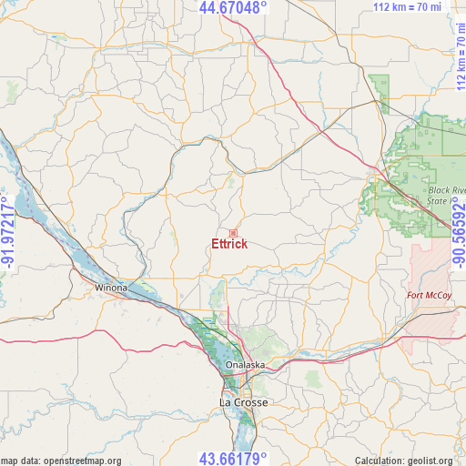
Ettrick GPS coordinates[2]
44° 10' 5.844" North, 91° 16' 8.544" West
| Map corner | latitude | longitude |
|---|---|---|
| Upper-left | 44.67048°, | -91.97217° |
| Center: | 44.16829°, | -91.26904° |
| Lower-right: | 43.66179°, | -90.56592° |
| Map W x H: | 112.2×112.2 km | = 69.7×69.7mi |
| max Lat: | 71.29058° ⇑10.9% North |
| Ettrick: | 44.16829° |
| min Lat: | ⇓89.1% South 19.06759° |
| min Long | Ettrick | max Long |
| -171.73463° | -91.26904° | -66.98998° |
| W 37.4%⇐ | ⇒62.6% E |
Elevation
Elevation of Ettrick is 235 m = 771 ft, and this is 59.8 m = 196 ft below average elevation for this country.
| Max E: |
3189 m = 10463 ft | 41% |
| Avg. | 294.8 m = 967 ft | |
| Ettrick | 235 m = 771 ft | |
Min E: |
-60 m = -197 ft | 59% |
See also: United States elevation on elevation.city.
Geographical zone
Ettrick is located in North temperate zone (between Tropic of Cancer and the Arctic Circle). Distance of this Northern Tropic circle is 2305.1 km =1432.3 mi to South.| Distance of | km | miles | from Ettrick |
|---|---|---|---|
| North Pole | 5096 | 3166.5 | to North |
| Arctic Circle | 2490.1 | 1547.3 | to North |
| Tropic Cancer | 2305.1 | 1432.3 | to South |
| Equator | 4911.1 | 3051.6 | to South |


Nearby cities:
15 places around Ettrick: (largest is in red/bold)
• Arcadia
20.8 km =12.9 mi,  296°
296°
• Black River Falls
36.1 km =22.4 mi,  67°
67°
• Blair
14.3 km =8.9 mi,  10°
10°
• Brice Prairie
25.7 km =16 mi,  185°
185°
• French Island
34.5 km =21.4 mi,  178°
178°
• Galesville
11.6 km =7.2 mi,  213°
213°
• Goodview
36 km =22.4 mi,  250°
250°
• Holmen
22.8 km =14.2 mi, 177°
• Independence
24.2 km =15 mi,  330°
330°
• North La Crosse
35.8 km =22.2 mi, 177°
• Onalaska
31.7 km =19.7 mi, 175°
• Trempealeau
22.8 km =14.2 mi,  217°
217°
• West Salem
33.5 km =20.8 mi,  153°
153°
• Whitehall
22.5 km =14 mi,  350°
350°
• Winona
32.4 km =20.1 mi, 246°
Sources, notices
• [Note1] Compared only with cities in United States existing in our database
• [Src1] Map data: © OpenStreetMap contributors (CC-BY-SA)
• [Src2] Other city data from geonames.org with taken over terms of usage.
• [Src3] Geographical zone / Annual Mean Temperature by Robert A. Rohde @ Wikipedia
