Grafton geodata
Grafton (Wisconsin) is a populated place; located in United States in America/Chicago (GMT-5) time zone. With population of 11,527 people, there are 4020 cities with bigger population in this country. Compared to other cities in United States, 85.5% of cities are located further ↓South; 52.6% of cities are located further →East and 58.4% of cities have lower elevation than Grafton. Note1


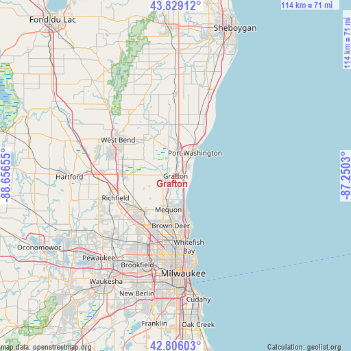
Grafton GPS coordinates[2]
43° 19' 11.028" North, 87° 57' 12.312" West
| Map corner | latitude | longitude |
|---|---|---|
| Upper-left | 43.82912°, | -88.65655° |
| Center: | 43.31973°, | -87.95342° |
| Lower-right: | 42.80603°, | -87.2503° |
| Map W x H: | 113.8×113.8 km | = 70.7×70.7mi |
| max Lat: | 71.29058° ⇑14.5% North |
| Grafton: | 43.31973° |
| min Lat: | ⇓85.5% South 19.06759° |
| min Long | Grafton | max Long |
| -171.73463° | -87.95342° | -66.98998° |
| W 47.4%⇐ | ⇒52.6% E |
Elevation
Elevation of Grafton is 232 m = 761 ft, and this is 62.8 m = 206 ft below average elevation for this country.
| Max E: |
3189 m = 10463 ft | 41.6% |
| Avg. | 294.8 m = 967 ft | |
| Grafton | 232 m = 761 ft | |
Min E: |
-60 m = -197 ft | 58.4% |
See also: United States elevation on elevation.city.
Geographical zone
Grafton is located in North temperate zone (between Tropic of Cancer and the Arctic Circle). Distance of this Northern Tropic circle is 2210.8 km =1373.7 mi to South.| Distance of | km | miles | from Grafton |
|---|---|---|---|
| North Pole | 5190.4 | 3225.2 | to North |
| Arctic Circle | 2584.5 | 1605.9 | to North |
| Tropic Cancer | 2210.8 | 1373.7 | to South |
| Equator | 4816.7 | 2993 | to South |


Nearby cities:
15 places around Grafton: (largest is in red/bold)
• Bayside
16.1 km =10 mi,  164°
164°
• Brown Deer
17.4 km =10.8 mi,  182°
182°
• Cedarburg
3.8 km =2.4 mi,  227°
227°
• Fox Point
18.5 km =11.5 mi,  166°
166°
• Fredonia
16.8 km =10.4 mi,  0°
0°
• Germantown
16.3 km =10.1 mi, 231°
• Jackson
17.3 km =10.7 mi,  271°
271°
• Kohler
20.4 km =12.7 mi,  343°
343°
• Mequon
13.1 km =8.1 mi,  208°
208°
• Newburg
14.5 km =9 mi,  328°
328°
• Port Washington
9.8 km =6.1 mi,  39°
39°
• River Hills
16.4 km =10.2 mi, 171°
• Saukville
7 km =4.3 mi,  8°
8°
• Thiensville
9.4 km =5.8 mi,  192°
192°
• Waubeka
17.5 km =10.9 mi,  350°
350°
Sources, notices
• [Note1] Compared only with cities in United States existing in our database
• [Src1] Map data: © OpenStreetMap contributors (CC-BY-SA)
• [Src2] Other city data from geonames.org with taken over terms of usage.
• [Src3] Geographical zone / Annual Mean Temperature by Robert A. Rohde @ Wikipedia
