Kohler geodata
Kohler (Wisconsin) is a populated place; located in United States in America/Chicago (GMT-5) time zone. With population of 1,955 people, there are 12075 cities with bigger population in this country. Compared to other cities in United States, 86.3% of cities are located further ↓South; 53% of cities are located further →East and 66.1% of cities have lower elevation than Kohler. Note1


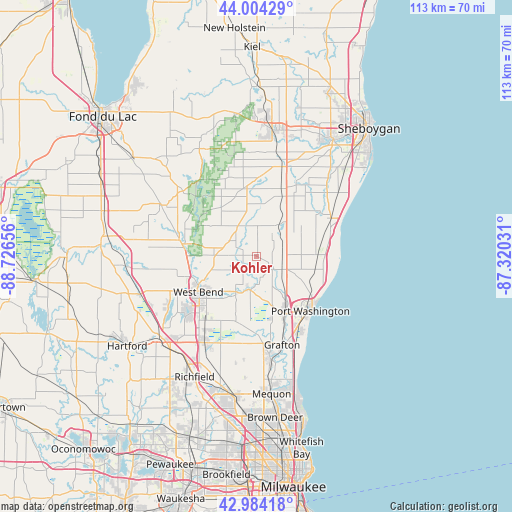
Kohler GPS coordinates[2]
43° 29' 47.004" North, 88° 1' 24.348" West
| Map corner | latitude | longitude |
|---|---|---|
| Upper-left | 44.00429°, | -88.72656° |
| Center: | 43.49639°, | -88.02343° |
| Lower-right: | 42.98418°, | -87.32031° |
| Map W x H: | 113.4×113.4 km | = 70.5×70.5mi |
| max Lat: | 71.29058° ⇑13.7% North |
| Kohler: | 43.49639° |
| min Lat: | ⇓86.3% South 19.06759° |
| min Long | Kohler | max Long |
| -171.73463° | -88.02343° | -66.98998° |
| W 47%⇐ | ⇒53% E |
Elevation
Elevation of Kohler is 267 m = 876 ft, and this is 27.8 m = 91 ft below average elevation for this country.
| Max E: |
3189 m = 10463 ft | 33.9% |
| Avg. | 294.8 m = 967 ft | |
| Kohler | 267 m = 876 ft | |
Min E: |
-60 m = -197 ft | 66.1% |
See also: United States elevation on elevation.city.
Geographical zone
Kohler is located in North temperate zone (between Tropic of Cancer and the Arctic Circle). Distance of this Northern Tropic circle is 2230.4 km =1385.9 mi to South.| Distance of | km | miles | from Kohler |
|---|---|---|---|
| North Pole | 5170.7 | 3212.9 | to North |
| Arctic Circle | 2564.8 | 1593.7 | to North |
| Tropic Cancer | 2230.4 | 1385.9 | to South |
| Equator | 4836.3 | 3005.1 | to South |


Nearby cities:
15 places around Kohler: (largest is in red/bold)
• Adell
14.8 km =9.2 mi,  22°
22°
• Barton
14 km =8.7 mi,  245°
245°
• Belgium
14 km =8.7 mi,  88°
88°
• Cascade
18.1 km =11.2 mi,  4°
4°
• Cedar Grove
18.1 km =11.2 mi,  63°
63°
• Fredonia
6.5 km =4 mi,  116°
116°
• Grafton
20.4 km =12.7 mi,  163°
163°
• Hingham
18.1 km =11.2 mi,  29°
29°
• Kewaskum
16.8 km =10.4 mi,  279°
279°
• Newburg
7.4 km =4.6 mi,  194°
194°
• Port Washington
17 km =10.6 mi,  135°
135°
• Random Lake
8 km =5 mi,  38°
38°
• Saukville
14.4 km =8.9 mi,  152°
152°
• Waubeka
3.6 km =2.2 mi,  131°
131°
• West Bend
15.1 km =9.4 mi,  238°
238°
Sources, notices
• [Note1] Compared only with cities in United States existing in our database
• [Src1] Map data: © OpenStreetMap contributors (CC-BY-SA)
• [Src2] Other city data from geonames.org with taken over terms of usage.
• [Src3] Geographical zone / Annual Mean Temperature by Robert A. Rohde @ Wikipedia
