Kewaskum geodata
Kewaskum (Wisconsin) is a populated place; located in United States in America/Chicago (GMT-5) time zone. With population of 4,096 people, there are 8101 cities with bigger population in this country. Compared to other cities in United States, 86.4% of cities are located further ↓South; 53.8% of cities are located further →East and 71.1% of cities have lower elevation than Kewaskum. Note1
Administrative division(s):
- Level 1: Wisconsin
- Level 2: Washington County
- Level 3: Village of Kewaskum


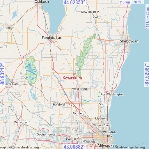
Kewaskum GPS coordinates[2]
43° 31' 14.988" North, 88° 13' 44.364" West
| Map corner | latitude | longitude |
|---|---|---|
| Upper-left | 44.02853°, | -88.93212° |
| Center: | 43.52083°, | -88.22899° |
| Lower-right: | 43.00882°, | -87.52587° |
| Map W x H: | 113.4×113.4 km | = 70.5×70.5mi |
| max Lat: | 71.29058° ⇑13.6% North |
| Kewaskum: | 43.52083° |
| min Lat: | ⇓86.4% South 19.06759° |
| min Long | Kewaskum | max Long |
| -171.73463° | -88.22899° | -66.98998° |
| W 46.2%⇐ | ⇒53.8% E |
Elevation
Elevation of Kewaskum is 291 m = 955 ft, and this is 3.8 m = 12 ft below average elevation for this country.
| Max E: |
3189 m = 10463 ft | 28.9% |
| Avg. | 294.8 m = 967 ft | |
| Kewaskum | 291 m = 955 ft | |
Min E: |
-60 m = -197 ft | 71.1% |
See also: United States elevation on elevation.city.
Geographical zone
Kewaskum is located in North temperate zone (between Tropic of Cancer and the Arctic Circle). Distance of this Northern Tropic circle is 2233.1 km =1387.6 mi to South.| Distance of | km | miles | from Kewaskum |
|---|---|---|---|
| North Pole | 5168 | 3211.2 | to North |
| Arctic Circle | 2562.1 | 1592 | to North |
| Tropic Cancer | 2233.1 | 1387.6 | to South |
| Equator | 4839.1 | 3006.9 | to South |


Nearby cities:
15 places around Kewaskum: (largest is in red/bold)
• Addison
16 km =9.9 mi,  227°
227°
• Allenton
14.3 km =8.9 mi,  219°
219°
• Ashford
13.6 km =8.5 mi,  302°
302°
• Barton
9.4 km =5.8 mi,  155°
155°
• Campbellsport
9.5 km =5.9 mi,  334°
334°
• Eden
22 km =13.7 mi, 331°
• Jackson
22.5 km =14 mi,  167°
167°
• Kohler
16.8 km =10.4 mi,  99°
99°
• Lomira
19 km =11.8 mi,  294°
294°
• Newburg
17.8 km =11.1 mi,  123°
123°
• Random Lake
21.8 km =13.5 mi,  80°
80°
• Slinger
21.3 km =13.2 mi,  192°
192°
• Theresa
17.9 km =11.1 mi,  268°
268°
• Waubeka
19.9 km =12.4 mi, 104°
• West Bend
11.2 km =7 mi, 160°
Sources, notices
• [Note1] Compared only with cities in United States existing in our database
• [Src1] Map data: © OpenStreetMap contributors (CC-BY-SA)
• [Src2] Other city data from geonames.org with taken over terms of usage.
• [Src3] Geographical zone / Annual Mean Temperature by Robert A. Rohde @ Wikipedia
