Mosinee geodata
Mosinee (Wisconsin) is a populated place; located in United States in America/Chicago (GMT-5) time zone. With population of 4,030 people, there are 8179 cities with bigger population in this country. Compared to other cities in United States, 91.6% of cities are located further ↓South; 58.2% of cities are located further →East and 80.1% of cities have lower elevation than Mosinee. Note1


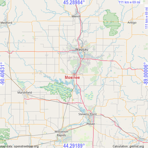
Mosinee GPS coordinates[2]
44° 47' 34.872" North, 89° 42' 11.448" West
| Map corner | latitude | longitude |
|---|---|---|
| Upper-left | 45.28984°, | -90.40631° |
| Center: | 44.79302°, | -89.70318° |
| Lower-right: | 44.29189°, | -89.00006° |
| Map W x H: | 111×111 km | = 69×69mi |
| max Lat: | 71.29058° ⇑8.4% North |
| Mosinee: | 44.79302° |
| min Lat: | ⇓91.6% South 19.06759° |
| min Long | Mosinee | max Long |
| -171.73463° | -89.70318° | -66.98998° |
| W 41.8%⇐ | ⇒58.2% E |
Elevation
Elevation of Mosinee is 355 m = 1165 ft, and this is 60.2 m = 198 ft above average elevation for this country.
| Max E: |
3189 m = 10463 ft | 19.9% |
| Mosinee | 355 m 1165 ft | |
| Avg. | 294.8 m = 967 ft | |
Min E: |
-60 m = -197 ft | 80.1% |
See also: United States elevation on elevation.city.
Geographical zone
Mosinee is located in North temperate zone (between Tropic of Cancer and the Arctic Circle). Distance of this Northern Tropic circle is 2374.6 km =1475.5 mi to South.| Distance of | km | miles | from Mosinee |
|---|---|---|---|
| North Pole | 5026.5 | 3123.3 | to North |
| Arctic Circle | 2420.7 | 1504.2 | to North |
| Tropic Cancer | 2374.6 | 1475.5 | to South |
| Equator | 4980.5 | 3094.7 | to South |


Nearby cities:
15 places around Mosinee: (largest is in red/bold)
• Auburndale
30.3 km =18.8 mi,  232°
232°
• Bevent
24.9 km =15.5 mi,  95°
95°
• Edgar
25.4 km =15.8 mi,  306°
306°
• Evergreen
7.5 km =4.7 mi,  43°
43°
• Hatley
30.6 km =19 mi,  69°
69°
• Kronenwetter
9.5 km =5.9 mi, 69°
• Maine
26.1 km =16.2 mi,  2°
2°
• Marathon
18.6 km =11.6 mi,  324°
324°
• Rib Mountain
13.5 km =8.4 mi,  9°
9°
• Rothschild
12.3 km =7.6 mi,  32°
32°
• Schofield
15.1 km =9.4 mi, 30°
• Sherry
28.7 km =17.8 mi,  215°
215°
• Stratford
29.7 km =18.5 mi,  271°
271°
• Wausau
19.3 km =12 mi,  17°
17°
• Weston
16.4 km =10.2 mi,  48°
48°
Sources, notices
• [Note1] Compared only with cities in United States existing in our database
• [Src1] Map data: © OpenStreetMap contributors (CC-BY-SA)
• [Src2] Other city data from geonames.org with taken over terms of usage.
• [Src3] Geographical zone / Annual Mean Temperature by Robert A. Rohde @ Wikipedia
