Oshkosh geodata
Oshkosh (Wisconsin) is a seat of a second-order administrative division; located in United States in America/Chicago (GMT-5) time zone. With population of 66,555 people, there are 638 cities with bigger population in this country. Compared to other cities in United States, 88.5% of cities are located further ↓South; 54.9% of cities are located further →East and 59.4% of cities have lower elevation than Oshkosh. Note1


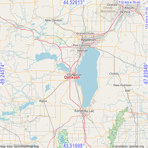
Oshkosh GPS coordinates[2]
44° 1' 28.956" North, 88° 32' 33.396" West
| Map corner | latitude | longitude |
|---|---|---|
| Upper-left | 44.52813°, | -89.24574° |
| Center: | 44.02471°, | -88.54261° |
| Lower-right: | 43.51698°, | -87.83949° |
| Map W x H: | 112.4×112.4 km | = 69.8×69.8mi |
| max Lat: | 71.29058° ⇑11.5% North |
| Oshkosh: | 44.02471° |
| min Lat: | ⇓88.5% South 19.06759° |
| min Long | Oshkosh | max Long |
| -171.73463° | -88.54261° | -66.98998° |
| W 45.1%⇐ | ⇒54.9% E |
Elevation
Elevation of Oshkosh is 237 m = 778 ft, and this is 57.8 m = 190 ft below average elevation for this country.
| Max E: |
3189 m = 10463 ft | 40.6% |
| Avg. | 294.8 m = 967 ft | |
| Oshkosh | 237 m = 778 ft | |
Min E: |
-60 m = -197 ft | 59.4% |
See also: Oshkosh elevation on elevation.city.
Geographical zone
Oshkosh is located in North temperate zone (between Tropic of Cancer and the Arctic Circle). Distance of this Northern Tropic circle is 2289.2 km =1422.4 mi to South.| Distance of | km | miles | from Oshkosh |
|---|---|---|---|
| North Pole | 5112 | 3176.4 | to North |
| Arctic Circle | 2506.1 | 1557.2 | to North |
| Tropic Cancer | 2289.2 | 1422.4 | to South |
| Equator | 4895.1 | 3041.7 | to South |


Nearby cities:
15 places around Oshkosh: (largest is in red/bold)
• Brothertown
19.7 km =12.2 mi,  108°
108°
• Butte des Morts
12.2 km =7.6 mi,  313°
313°
• Eldorado
23.1 km =14.4 mi,  195°
195°
• Harrison
28 km =17.4 mi,  36°
36°
• Menasha
21.2 km =13.2 mi,  21°
21°
• Neenah
19 km =11.8 mi, 19°
• North Fond du Lac
24.2 km =15 mi,  168°
168°
• Omro
16.2 km =10.1 mi,  275°
275°
• Rosendale
26.3 km =16.3 mi, 203°
• Saint Peter
26.4 km =16.4 mi,  142°
142°
• Sherwood
28 km =17.4 mi,  53°
53°
• Stockbridge
20.2 km =12.6 mi,  74°
74°
• Taycheedah
26.7 km =16.6 mi,  153°
153°
• Winchester
21.7 km =13.5 mi,  333°
333°
• Winneconne
16.6 km =10.3 mi, 305°
Sources, notices
• [Note1] Compared only with cities in United States existing in our database
• [Src1] Map data: © OpenStreetMap contributors (CC-BY-SA)
• [Src2] Other city data from geonames.org with taken over terms of usage.
• [Src3] Geographical zone / Annual Mean Temperature by Robert A. Rohde @ Wikipedia
