Brothertown geodata
Brothertown (Wisconsin) is a populated place; located in United States in America/Chicago (GMT-5) time zone. With population of 1,321 people, there are 14483 cities with bigger population in this country. Compared to other cities in United States, 88.2% of cities are located further ↓South; 54.1% of cities are located further →East and 61.9% of cities have lower elevation than Brothertown. Note1


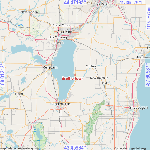
Brothertown GPS coordinates[2]
43° 58' 4.98" North, 88° 18' 32.364" West
| Map corner | latitude | longitude |
|---|---|---|
| Upper-left | 44.47195°, | -89.01212° |
| Center: | 43.96805°, | -88.30899° |
| Lower-right: | 43.45984°, | -87.60587° |
| Map W x H: | 112.5×112.5 km | = 69.9×69.9mi |
| max Lat: | 71.29058° ⇑11.8% North |
| Brothertown: | 43.96805° |
| min Lat: | ⇓88.2% South 19.06759° |
| min Long | Brothertown | max Long |
| -171.73463° | -88.30899° | -66.98998° |
| W 45.9%⇐ | ⇒54.1% E |
Elevation
Elevation of Brothertown is 248 m = 814 ft, and this is 46.8 m = 154 ft below average elevation for this country.
| Max E: |
3189 m = 10463 ft | 38.1% |
| Avg. | 294.8 m = 967 ft | |
| Brothertown | 248 m = 814 ft | |
Min E: |
-60 m = -197 ft | 61.9% |
See also: United States elevation on elevation.city.
Geographical zone
Brothertown is located in North temperate zone (between Tropic of Cancer and the Arctic Circle). Distance of this Northern Tropic circle is 2282.9 km =1418.5 mi to South.| Distance of | km | miles | from Brothertown |
|---|---|---|---|
| North Pole | 5118.3 | 3180.4 | to North |
| Arctic Circle | 2512.4 | 1561.1 | to North |
| Tropic Cancer | 2282.9 | 1418.5 | to South |
| Equator | 4888.8 | 3037.8 | to South |


Nearby cities:
15 places around Brothertown: (largest is in red/bold)
• Chilton
13.5 km =8.4 mi,  59°
59°
• Elkhart Lake
27.7 km =17.2 mi,  122°
122°
• Fond du Lac
23.9 km =14.9 mi,  205°
205°
• Hilbert
22.4 km =13.9 mi,  31°
31°
• Kiel
22.7 km =14.1 mi,  105°
105°
• Menasha
28.3 km =17.6 mi,  337°
337°
• Mount Calvary
16.5 km =10.3 mi,  162°
162°
• Neenah
27.1 km =16.8 mi,  333°
333°
• New Holstein
18.1 km =11.2 mi,  96°
96°
• North Fond du Lac
22.3 km =13.9 mi,  218°
218°
• Oshkosh
19.7 km =12.2 mi,  288°
288°
• Saint Peter
14.9 km =9.3 mi,  190°
190°
• Sherwood
23.2 km =14.4 mi,  9°
9°
• Stockbridge
11.5 km =7.1 mi,  3°
3°
• Taycheedah
19 km =11.8 mi,  201°
201°
Sources, notices
• [Note1] Compared only with cities in United States existing in our database
• [Src1] Map data: © OpenStreetMap contributors (CC-BY-SA)
• [Src2] Other city data from geonames.org with taken over terms of usage.
• [Src3] Geographical zone / Annual Mean Temperature by Robert A. Rohde @ Wikipedia
