Sherwood geodata
Sherwood (Wisconsin) is a populated place; located in United States in America/Chicago (GMT-5) time zone. With population of 2,865 people, there are 9883 cities with bigger population in this country. Compared to other cities in United States, 89.1% of cities are located further ↓South; 53.9% of cities are located further →East and 67.6% of cities have lower elevation than Sherwood. Note1


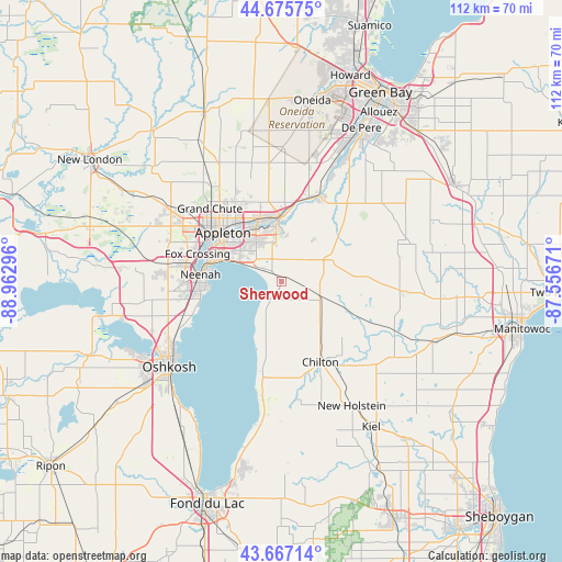
Sherwood GPS coordinates[2]
44° 10' 24.96" North, 88° 15' 35.388" West
| Map corner | latitude | longitude |
|---|---|---|
| Upper-left | 44.67575°, | -88.96296° |
| Center: | 44.1736°, | -88.25983° |
| Lower-right: | 43.66714°, | -87.55671° |
| Map W x H: | 112.1×112.1 km | = 69.7×69.7mi |
| max Lat: | 71.29058° ⇑10.9% North |
| Sherwood: | 44.1736° |
| min Lat: | ⇓89.1% South 19.06759° |
| min Long | Sherwood | max Long |
| -171.73463° | -88.25983° | -66.98998° |
| W 46.1%⇐ | ⇒53.9% E |
Elevation
Elevation of Sherwood is 274 m = 899 ft, and this is 20.8 m = 68 ft below average elevation for this country.
| Max E: |
3189 m = 10463 ft | 32.4% |
| Avg. | 294.8 m = 967 ft | |
| Sherwood | 274 m = 899 ft | |
Min E: |
-60 m = -197 ft | 67.6% |
See also: United States elevation on elevation.city.
Geographical zone
Sherwood is located in North temperate zone (between Tropic of Cancer and the Arctic Circle). Distance of this Northern Tropic circle is 2305.7 km =1432.7 mi to South.| Distance of | km | miles | from Sherwood |
|---|---|---|---|
| North Pole | 5095.4 | 3166.1 | to North |
| Arctic Circle | 2489.5 | 1546.9 | to North |
| Tropic Cancer | 2305.7 | 1432.7 | to South |
| Equator | 4911.6 | 3051.9 | to South |


Nearby cities:
15 places around Sherwood: (largest is in red/bold)
• Appleton
15.8 km =9.8 mi,  308°
308°
• Brillion
15.6 km =9.7 mi,  88°
88°
• Chilton
17.9 km =11.1 mi,  154°
154°
• Combined Locks
11.1 km =6.9 mi,  337°
337°
• Forest Junction
10.2 km =6.3 mi,  64°
64°
• Greenleaf
20.3 km =12.6 mi,  39°
39°
• Harrison
8.5 km =5.3 mi, 314°
• Hilbert
8.5 km =5.3 mi,  115°
115°
• Kaukauna
11.7 km =7.3 mi,  355°
355°
• Kimberly
12.6 km =7.8 mi,  330°
330°
• Little Chute
12.7 km =7.9 mi, 338°
• Menasha
15.2 km =9.4 mi,  282°
282°
• Neenah
16.2 km =10.1 mi,  274°
274°
• Stockbridge
11.8 km =7.3 mi,  195°
195°
• Wrightstown
18.6 km =11.6 mi,  24°
24°
Sources, notices
• [Note1] Compared only with cities in United States existing in our database
• [Src1] Map data: © OpenStreetMap contributors (CC-BY-SA)
• [Src2] Other city data from geonames.org with taken over terms of usage.
• [Src3] Geographical zone / Annual Mean Temperature by Robert A. Rohde @ Wikipedia
