Shiocton geodata
Shiocton (Wisconsin) is a populated place; located in United States in America/Chicago (GMT-5) time zone. With population of 921 people, there are 16858 cities with bigger population in this country. Compared to other cities in United States, 90.2% of cities are located further ↓South; 55% of cities are located further →East and 59.9% of cities have lower elevation than Shiocton. Note1
Administrative division(s):
- Level 1: Wisconsin
- Level 2: Outagamie County
- Level 3: Village of Shiocton


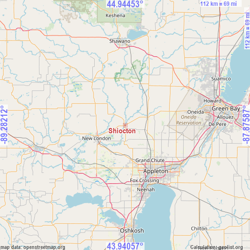
Shiocton GPS coordinates[2]
44° 26' 40.956" North, 88° 34' 44.364" West
| Map corner | latitude | longitude |
|---|---|---|
| Upper-left | 44.94453°, | -89.28212° |
| Center: | 44.44471°, | -88.57899° |
| Lower-right: | 43.94057°, | -87.87587° |
| Map W x H: | 111.6×111.6 km | = 69.3×69.3mi |
| max Lat: | 71.29058° ⇑9.8% North |
| Shiocton: | 44.44471° |
| min Lat: | ⇓90.2% South 19.06759° |
| min Long | Shiocton | max Long |
| -171.73463° | -88.57899° | -66.98998° |
| W 45%⇐ | ⇒55% E |
Elevation
Elevation of Shiocton is 239 m = 784 ft, and this is 55.8 m = 183 ft below average elevation for this country.
| Max E: |
3189 m = 10463 ft | 40.1% |
| Avg. | 294.8 m = 967 ft | |
| Shiocton | 239 m = 784 ft | |
Min E: |
-60 m = -197 ft | 59.9% |
See also: United States elevation on elevation.city.
Geographical zone
Shiocton is located in North temperate zone (between Tropic of Cancer and the Arctic Circle). Distance of this Northern Tropic circle is 2335.9 km =1451.5 mi to South.| Distance of | km | miles | from Shiocton |
|---|---|---|---|
| North Pole | 5065.3 | 3147.4 | to North |
| Arctic Circle | 2459.4 | 1528.2 | to North |
| Tropic Cancer | 2335.9 | 1451.5 | to South |
| Equator | 4941.8 | 3070.7 | to South |


Nearby cities:
15 places around Shiocton: (largest is in red/bold)
• Appleton
24.1 km =15 mi,  147°
147°
• Black Creek
10.8 km =6.7 mi,  70°
70°
• Clintonville
24.4 km =15.2 mi,  323°
323°
• Combined Locks
29 km =18 mi,  133°
133°
• Dale
20.7 km =12.9 mi,  202°
202°
• Hortonville
13.1 km =8.1 mi, 201°
• Kaukauna
30.6 km =19 mi, 127°
• Kimberly
27.1 km =16.8 mi,  135°
135°
• Little Chute
27.6 km =17.1 mi, 131°
• Manawa
27.1 km =16.8 mi,  274°
274°
• Menasha
28.9 km =18 mi,  158°
158°
• Neenah
30.2 km =18.8 mi, 162°
• New London
14 km =8.7 mi,  245°
245°
• Seymour
21.2 km =13.2 mi, 68°
• Winchester
28.2 km =17.5 mi,  194°
194°
Sources, notices
• [Note1] Compared only with cities in United States existing in our database
• [Src1] Map data: © OpenStreetMap contributors (CC-BY-SA)
• [Src2] Other city data from geonames.org with taken over terms of usage.
• [Src3] Geographical zone / Annual Mean Temperature by Robert A. Rohde @ Wikipedia
