South Milwaukee geodata
South Milwaukee (Wisconsin) is a populated place; located in United States in America/Chicago (GMT-5) time zone. With population of 21,233 people, there are 2375 cities with bigger population in this country. Compared to other cities in United States, 82.6% of cities are located further ↓South; 52.2% of cities are located further →East and 51.7% of cities have lower elevation than South Milwaukee. Note1
Administrative division(s):
- Level 1: Wisconsin
- Level 2: Milwaukee County
- Level 3: City of South Milwaukee


South Milwaukee GPS coordinates[2]
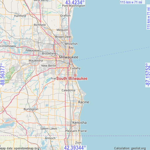
42° 54' 38.052" North, 87° 51' 38.304" West
| Map corner | latitude | longitude |
|---|---|---|
| Upper-left | 43.4234°, | -88.56377° |
| Center: | 42.91057°, | -87.86064° |
| Lower-right: | 42.39344°, | -87.15752° |
| Map W x H: | 114.5×114.5 km | = 71.1×71.1mi |
| max Lat: | 71.29058° ⇑17.4% North |
| South Milwaukee: | 42.91057° |
| min Lat: | ⇓82.6% South 19.06759° |
| min Long | South Milwaukee | max Long |
| -171.73463° | -87.86064° | -66.98998° |
| W 47.8%⇐ | ⇒52.2% E |
Elevation
Elevation of South Milwaukee is 205 m = 673 ft, and this is 89.8 m = 295 ft below average elevation for this country.
| Max E: |
3189 m = 10463 ft | 48.3% |
| Avg. | 294.8 m = 967 ft | |
| South Milwaukee | 205 m = 673 ft | |
Min E: |
-60 m = -197 ft | 51.7% |
See also: United States elevation on elevation.city.
Geographical zone
South Milwaukee is located in North temperate zone (between Tropic of Cancer and the Arctic Circle). Distance of this Northern Tropic circle is 2165.3 km =1345.5 mi to South.| Distance of | km | miles | from South Milwaukee |
|---|---|---|---|
| North Pole | 5235.9 | 3253.4 | to North |
| Arctic Circle | 2630 | 1634.2 | to North |
| Tropic Cancer | 2165.3 | 1345.5 | to South |
| Equator | 4771.2 | 2964.7 | to South |


Nearby cities:
15 places around South Milwaukee: (largest is in red/bold)
• Caledonia
12.5 km =7.8 mi,  204°
204°
• Cudahy
5.5 km =3.4 mi,  359°
359°
• Franklin
14.7 km =9.1 mi,  260°
260°
• Franksville
17.3 km =10.7 mi,  194°
194°
• Greendale
11.5 km =7.1 mi,  286°
286°
• Greenfield
13.6 km =8.5 mi, 294°
• Hales Corners
15.6 km =9.7 mi,  281°
281°
• Milwaukee
14.7 km =9.1 mi,  345°
345°
• Oak Creek
2.8 km =1.7 mi,  184°
184°
• Saint Francis
6.5 km =4 mi, 347°
• Shorewood
20 km =12.4 mi, 353°
• Wauwatosa
19.5 km =12.1 mi,  322°
322°
• West Allis
16.8 km =10.4 mi,  314°
314°
• West Milwaukee
14.5 km =9 mi, 321°
• Wind Point
16 km =9.9 mi,  151°
151°
Sources, notices
• [Note1] Compared only with cities in United States existing in our database
• [Src1] Map data: © OpenStreetMap contributors (CC-BY-SA)
• [Src2] Other city data from geonames.org with taken over terms of usage.
• [Src3] Geographical zone / Annual Mean Temperature by Robert A. Rohde @ Wikipedia
