West Milwaukee geodata
West Milwaukee (Wisconsin) is a populated place; located in United States in America/Chicago (GMT-5) time zone. With population of 4,212 people, there are 7967 cities with bigger population in this country. Compared to other cities in United States, 83.4% of cities are located further ↓South; 52.7% of cities are located further →East and 50.7% of cities have lower elevation than West Milwaukee. Note1
Administrative division(s):
- Level 1: Wisconsin
- Level 2: Milwaukee County
- Level 3: Village of West Milwaukee


West Milwaukee GPS coordinates[2]
43° 0' 45.036" North, 87° 58' 21.324" West
| Map corner | latitude | longitude |
|---|---|---|
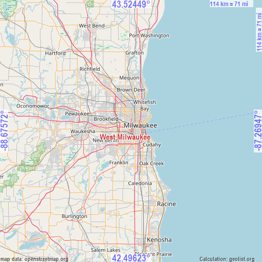
| Upper-left | 43.52449°, | -88.67572° |
| Center: | 43.01251°, | -87.97259° |
| Lower-right: | 42.49623°, | -87.26947° |
| Map W x H: | 114.3×114.3 km | = 71×71mi |
| max Lat: | 71.29058° ⇑16.6% North |
| West Milwaukee: | 43.01251° |
| min Lat: | ⇓83.4% South 19.06759° |
| min Long | West Milwaukee | max Long |
| -171.73463° | -87.97259° | -66.98998° |
| W 47.3%⇐ | ⇒52.7% E |
Elevation
Elevation of West Milwaukee is 201 m = 659 ft, and this is 93.8 m = 308 ft below average elevation for this country.
| Max E: |
3189 m = 10463 ft | 49.3% |
| Avg. | 294.8 m = 967 ft | |
| West Milwaukee | 201 m = 659 ft | |
Min E: |
-60 m = -197 ft | 50.7% |
See also: United States elevation on elevation.city.
Geographical zone
West Milwaukee is located in North temperate zone (between Tropic of Cancer and the Arctic Circle). Distance of this Northern Tropic circle is 2176.6 km =1352.5 mi to South.| Distance of | km | miles | from West Milwaukee |
|---|---|---|---|
| North Pole | 5224.5 | 3246.4 | to North |
| Arctic Circle | 2618.6 | 1627.1 | to North |
| Tropic Cancer | 2176.6 | 1352.5 | to South |
| Equator | 4782.5 | 2971.7 | to South |


Nearby cities:
15 places around West Milwaukee: (largest is in red/bold)
• Brookfield
12.1 km =7.5 mi,  296°
296°
• Butler
13 km =8.1 mi,  322°
322°
• Cudahy
10.8 km =6.7 mi,  122°
122°
• Elm Grove
9.3 km =5.8 mi,  291°
291°
• Glendale
14 km =8.7 mi,  12°
12°
• Greendale
8.2 km =5.1 mi,  193°
193°
• Greenfield
6.5 km =4 mi,  209°
209°
• Hales Corners
10.4 km =6.5 mi,  216°
216°
• Milwaukee
6.1 km =3.8 mi,  61°
61°
• New Berlin
11.8 km =7.3 mi,  250°
250°
• Saint Francis
9.2 km =5.7 mi, 122°
• Shorewood
11 km =6.8 mi,  39°
39°
• Wauwatosa
5 km =3.1 mi,  325°
325°
• West Allis
2.8 km =1.7 mi,  279°
279°
• Whitefish Bay
12.7 km =7.9 mi,  27°
27°
Sources, notices
• [Note1] Compared only with cities in United States existing in our database
• [Src1] Map data: © OpenStreetMap contributors (CC-BY-SA)
• [Src2] Other city data from geonames.org with taken over terms of usage.
• [Src3] Geographical zone / Annual Mean Temperature by Robert A. Rohde @ Wikipedia
