Wauwatosa geodata
Wauwatosa (Wisconsin) is a populated place; located in United States in America/Chicago (GMT-5) time zone. With population of 47,614 people, there are 1012 cities with bigger population in this country. Compared to other cities in United States, 83.7% of cities are located further ↓South; 52.9% of cities are located further →East and 50.7% of cities have lower elevation than Wauwatosa. Note1


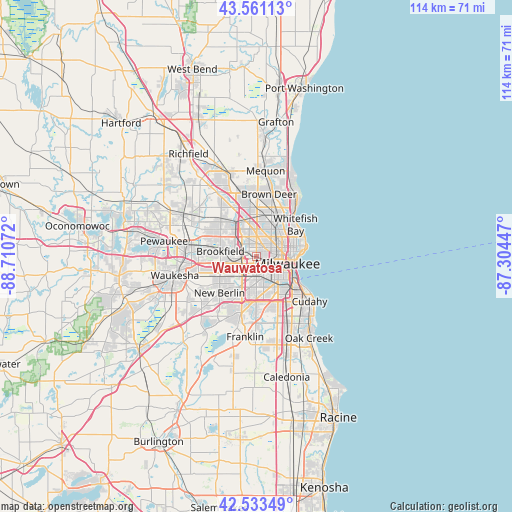
Wauwatosa GPS coordinates[2]
43° 2' 58.056" North, 88° 0' 27.324" West
| Map corner | latitude | longitude |
|---|---|---|
| Upper-left | 43.56113°, | -88.71072° |
| Center: | 43.04946°, | -88.00759° |
| Lower-right: | 42.53349°, | -87.30447° |
| Map W x H: | 114.3×114.3 km | = 71×71mi |
| max Lat: | 71.29058° ⇑16.3% North |
| Wauwatosa: | 43.04946° |
| min Lat: | ⇓83.7% South 19.06759° |
| min Long | Wauwatosa | max Long |
| -171.73463° | -88.00759° | -66.98998° |
| W 47.1%⇐ | ⇒52.9% E |
Elevation
Elevation of Wauwatosa is 201 m = 659 ft, and this is 93.8 m = 308 ft below average elevation for this country.
| Max E: |
3189 m = 10463 ft | 49.3% |
| Avg. | 294.8 m = 967 ft | |
| Wauwatosa | 201 m = 659 ft | |
Min E: |
-60 m = -197 ft | 50.7% |
See also: Wauwatosa elevation on elevation.city.
Geographical zone
Wauwatosa is located in North temperate zone (between Tropic of Cancer and the Arctic Circle). Distance of this Northern Tropic circle is 2180.7 km =1355 mi to South.| Distance of | km | miles | from Wauwatosa |
|---|---|---|---|
| North Pole | 5220.4 | 3243.8 | to North |
| Arctic Circle | 2614.5 | 1624.6 | to North |
| Tropic Cancer | 2180.7 | 1355 | to South |
| Equator | 4786.7 | 2974.3 | to South |


Nearby cities:
15 places around Wauwatosa: (largest is in red/bold)
• Brookfield
8.1 km =5 mi,  278°
278°
• Brown Deer
13.1 km =8.1 mi,  15°
15°
• Butler
8 km =5 mi,  321°
321°
• Elm Grove
5.8 km =3.6 mi,  263°
263°
• Glendale
11.2 km =7 mi,  31°
31°
• Greendale
12.1 km =7.5 mi,  175°
175°
• Greenfield
9.8 km =6.1 mi, 182°
• Hales Corners
12.9 km =8 mi,  195°
195°
• Milwaukee
8.3 km =5.2 mi,  98°
98°
• New Berlin
11.5 km =7.1 mi,  225°
225°
• Saint Francis
14 km =8.7 mi,  130°
130°
• Shorewood
10.7 km =6.6 mi,  65°
65°
• West Allis
3.6 km =2.2 mi, 179°
• West Milwaukee
5 km =3.1 mi,  145°
145°
• Whitefish Bay
11.3 km =7 mi,  50°
50°
Sources, notices
• [Note1] Compared only with cities in United States existing in our database
• [Src1] Map data: © OpenStreetMap contributors (CC-BY-SA)
• [Src2] Other city data from geonames.org with taken over terms of usage.
• [Src3] Geographical zone / Annual Mean Temperature by Robert A. Rohde @ Wikipedia
