Stoughton geodata
Stoughton (Wisconsin) is a populated place; located in United States in America/Chicago (GMT-5) time zone. With population of 13,067 people, there are 3652 cities with bigger population in this country. Compared to other cities in United States, 82.7% of cities are located further ↓South; 56.8% of cities are located further →East and 66.6% of cities have lower elevation than Stoughton. Note1


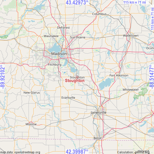
Stoughton GPS coordinates[2]
42° 55' 1.02" North, 89° 13' 4.404" West
| Map corner | latitude | longitude |
|---|---|---|
| Upper-left | 43.42973°, | -89.92102° |
| Center: | 42.91695°, | -89.21789° |
| Lower-right: | 42.39987°, | -88.51477° |
| Map W x H: | 114.5×114.5 km | = 71.1×71.1mi |
| max Lat: | 71.29058° ⇑17.3% North |
| Stoughton: | 42.91695° |
| min Lat: | ⇓82.7% South 19.06759° |
| min Long | Stoughton | max Long |
| -171.73463° | -89.21789° | -66.98998° |
| W 43.2%⇐ | ⇒56.8% E |
Elevation
Elevation of Stoughton is 269 m = 883 ft, and this is 25.8 m = 85 ft below average elevation for this country.
| Max E: |
3189 m = 10463 ft | 33.4% |
| Avg. | 294.8 m = 967 ft | |
| Stoughton | 269 m = 883 ft | |
Min E: |
-60 m = -197 ft | 66.6% |
See also: United States elevation on elevation.city.
Geographical zone
Stoughton is located in North temperate zone (between Tropic of Cancer and the Arctic Circle). Distance of this Northern Tropic circle is 2166 km =1345.9 mi to South.| Distance of | km | miles | from Stoughton |
|---|---|---|---|
| North Pole | 5235.1 | 3252.9 | to North |
| Arctic Circle | 2629.3 | 1633.8 | to North |
| Tropic Cancer | 2166 | 1345.9 | to South |
| Equator | 4771.9 | 2965.1 | to South |


Nearby cities:
15 places around Stoughton: (largest is in red/bold)
• Brooklyn
14.3 km =8.9 mi,  240°
240°
• Cambridge
19 km =11.8 mi,  59°
59°
• Cottage Grove
17.8 km =11.1 mi,  4°
4°
• Deerfield
19 km =11.8 mi,  37°
37°
• Edgerton
15.2 km =9.4 mi,  126°
126°
• Evansville
16.6 km =10.3 mi,  203°
203°
• Fitchburg
21.1 km =13.1 mi,  283°
283°
• Lake Koshkonong
24.3 km =15.1 mi,  91°
91°
• Lake Ripley
21.3 km =13.2 mi, 62°
• Madison
22.9 km =14.2 mi,  319°
319°
• McFarland
12.1 km =7.5 mi,  331°
331°
• Monona
18.7 km =11.6 mi, 329°
• Oregon
13.6 km =8.5 mi,  274°
274°
• Rutland
11.6 km =7.2 mi,  248°
248°
• Shorewood Hills
25.7 km =16 mi,  313°
313°
Sources, notices
• [Note1] Compared only with cities in United States existing in our database
• [Src1] Map data: © OpenStreetMap contributors (CC-BY-SA)
• [Src2] Other city data from geonames.org with taken over terms of usage.
• [Src3] Geographical zone / Annual Mean Temperature by Robert A. Rohde @ Wikipedia
