Brooklyn geodata
Brooklyn (Wisconsin) is a populated place; located in United States in America/Chicago (GMT-5) time zone. With population of 1,449 people, there are 13886 cities with bigger population in this country. Compared to other cities in United States, 82.2% of cities are located further ↓South; 57.2% of cities are located further →East and 73.3% of cities have lower elevation than Brooklyn. Note1


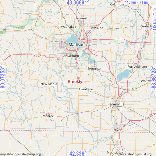
Brooklyn GPS coordinates[2]
42° 51' 12.996" North, 89° 22' 13.44" West
| Map corner | latitude | longitude |
|---|---|---|
| Upper-left | 43.36691°, | -90.07353° |
| Center: | 42.85361°, | -89.3704° |
| Lower-right: | 42.336°, | -88.66728° |
| Map W x H: | 114.6×114.6 km | = 71.2×71.2mi |
| max Lat: | 71.29058° ⇑17.8% North |
| Brooklyn: | 42.85361° |
| min Lat: | ⇓82.2% South 19.06759° |
| min Long | Brooklyn | max Long |
| -171.73463° | -89.3704° | -66.98998° |
| W 42.8%⇐ | ⇒57.2% E |
Elevation
Elevation of Brooklyn is 303 m = 994 ft, and this is 8.2 m = 27 ft above average elevation for this country.
| Max E: |
3189 m = 10463 ft | 26.7% |
| Brooklyn | 303 m 994 ft | |
| Avg. | 294.8 m = 967 ft | |
Min E: |
-60 m = -197 ft | 73.3% |
See also: United States elevation on elevation.city.
Geographical zone
Brooklyn is located in North temperate zone (between Tropic of Cancer and the Arctic Circle). Distance of this Northern Tropic circle is 2159 km =1341.5 mi to South.| Distance of | km | miles | from Brooklyn |
|---|---|---|---|
| North Pole | 5242.2 | 3257.4 | to North |
| Arctic Circle | 2636.3 | 1638.1 | to North |
| Tropic Cancer | 2159 | 1341.5 | to South |
| Equator | 4764.9 | 2960.8 | to South |


Nearby cities:
15 places around Brooklyn: (largest is in red/bold)
• Albany
17.1 km =10.6 mi,  198°
198°
• Belleville
13.7 km =8.5 mi,  272°
272°
• Decatur
24.6 km =15.3 mi,  187°
187°
• Evansville
10 km =6.2 mi,  144°
144°
• Fitchburg
14.4 km =8.9 mi,  325°
325°
• Footville
24.2 km =15 mi,  147°
147°
• Madison
24.5 km =15.2 mi,  354°
354°
• McFarland
18.8 km =11.7 mi,  20°
20°
• Monona
23.4 km =14.5 mi,  7°
7°
• Monticello
21.9 km =13.6 mi,  236°
236°
• New Glarus
22 km =13.7 mi,  258°
258°
• Oregon
8.1 km =5 mi, 351°
• Rutland
3.3 km =2.1 mi,  30°
30°
• Stoughton
14.3 km =8.9 mi,  60°
60°
• Verona
20.2 km =12.6 mi,  319°
319°
Sources, notices
• [Note1] Compared only with cities in United States existing in our database
• [Src1] Map data: © OpenStreetMap contributors (CC-BY-SA)
• [Src2] Other city data from geonames.org with taken over terms of usage.
• [Src3] Geographical zone / Annual Mean Temperature by Robert A. Rohde @ Wikipedia
