Evansville geodata
Evansville (Wisconsin) is a populated place; located in United States in America/Chicago (GMT-5) time zone. With population of 5,228 people, there are 6968 cities with bigger population in this country. Compared to other cities in United States, 81.7% of cities are located further ↓South; 57% of cities are located further →East and 69% of cities have lower elevation than Evansville. Note1


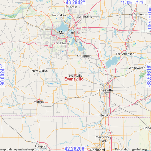
Evansville GPS coordinates[2]
42° 46' 49.008" North, 89° 17' 57.408" West
| Map corner | latitude | longitude |
|---|---|---|
| Upper-left | 43.2942°, | -90.00241° |
| Center: | 42.78028°, | -89.29928° |
| Lower-right: | 42.26206°, | -88.59616° |
| Map W x H: | 114.8×114.8 km | = 71.3×71.3mi |
| max Lat: | 71.29058° ⇑18.3% North |
| Evansville: | 42.78028° |
| min Lat: | ⇓81.7% South 19.06759° |
| min Long | Evansville | max Long |
| -171.73463° | -89.29928° | -66.98998° |
| W 43%⇐ | ⇒57% E |
Elevation
Elevation of Evansville is 281 m = 922 ft, and this is 13.8 m = 45 ft below average elevation for this country.
| Max E: |
3189 m = 10463 ft | 31% |
| Avg. | 294.8 m = 967 ft | |
| Evansville | 281 m = 922 ft | |
Min E: |
-60 m = -197 ft | 69% |
See also: United States elevation on elevation.city.
Geographical zone
Evansville is located in North temperate zone (between Tropic of Cancer and the Arctic Circle). Distance of this Northern Tropic circle is 2150.8 km =1336.4 mi to South.| Distance of | km | miles | from Evansville |
|---|---|---|---|
| North Pole | 5250.3 | 3262.4 | to North |
| Arctic Circle | 2644.5 | 1643.2 | to North |
| Tropic Cancer | 2150.8 | 1336.4 | to South |
| Equator | 4756.7 | 2955.7 | to South |


Nearby cities:
15 places around Evansville: (largest is in red/bold)
• Albany
13.8 km =8.6 mi,  234°
234°
• Belleville
21.4 km =13.3 mi,  294°
294°
• Brodhead
19.1 km =11.9 mi,  199°
199°
• Brooklyn
10 km =6.2 mi,  324°
324°
• Decatur
18.6 km =11.6 mi,  209°
209°
• Edgerton
19.9 km =12.4 mi,  72°
72°
• Fitchburg
24.4 km =15.2 mi,  325°
325°
• Footville
14.2 km =8.8 mi,  148°
148°
• Janesville
25.3 km =15.7 mi,  115°
115°
• McFarland
25.8 km =16 mi,  1°
1°
• Monticello
24.4 km =15.2 mi,  260°
260°
• Oregon
17.6 km =10.9 mi,  336°
336°
• Orfordville
17.4 km =10.8 mi,  167°
167°
• Rutland
11.7 km =7.3 mi, 339°
• Stoughton
16.6 km =10.3 mi,  23°
23°
Sources, notices
• [Note1] Compared only with cities in United States existing in our database
• [Src1] Map data: © OpenStreetMap contributors (CC-BY-SA)
• [Src2] Other city data from geonames.org with taken over terms of usage.
• [Src3] Geographical zone / Annual Mean Temperature by Robert A. Rohde @ Wikipedia
