Sturgeon Bay geodata
Sturgeon Bay (Wisconsin) is a seat of a second-order administrative division; located in United States in America/Chicago (GMT-5) time zone. With population of 8,956 people, there are 4825 cities with bigger population in this country. Compared to other cities in United States, 91.8% of cities are located further ↓South; 50.5% of cities are located further →East and 53.1% of cities have higher elevation than Sturgeon Bay. Note1


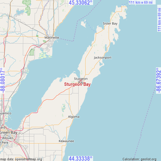
Sturgeon Bay GPS coordinates[2]
44° 50' 2.976" North, 87° 22' 37.344" West
| Map corner | latitude | longitude |
|---|---|---|
| Upper-left | 45.33062°, | -88.08017° |
| Center: | 44.83416°, | -87.37704° |
| Lower-right: | 44.33338°, | -86.67392° |
| Map W x H: | 110.9×110.9 km | = 68.9×68.9mi |
| max Lat: | 71.29058° ⇑8.2% North |
| Sturgeon Bay: | 44.83416° |
| min Lat: | ⇓91.8% South 19.06759° |
| min Long | Sturgeon Bay | max Long |
| -171.73463° | -87.37704° | -66.98998° |
| W 49.5%⇐ | ⇒50.5% E |
Elevation
Elevation of Sturgeon Bay is 187 m = 614 ft, and this is 107.8 m = 354 ft below average elevation for this country.
| Max E: |
3189 m = 10463 ft | 53.1% |
| Avg. | 294.8 m = 967 ft | |
| Sturgeon Bay | 187 m = 614 ft | |
Min E: |
-60 m = -197 ft | 46.9% |
See also: United States elevation on elevation.city.
Geographical zone
Sturgeon Bay is located in North temperate zone (between Tropic of Cancer and the Arctic Circle). Distance of this Northern Tropic circle is 2379.2 km =1478.4 mi to South.| Distance of | km | miles | from Sturgeon Bay |
|---|---|---|---|
| North Pole | 5022 | 3120.5 | to North |
| Arctic Circle | 2416.1 | 1501.3 | to North |
| Tropic Cancer | 2379.2 | 1478.4 | to South |
| Equator | 4985.1 | 3097.6 | to South |


Nearby cities:
15 places around Sturgeon Bay: (largest is in red/bold)
• Algoma
25.4 km =15.8 mi,  189°
189°
• Brussels
22.1 km =13.7 mi,  240°
240°
• Casco
36.2 km =22.5 mi,  211°
211°
• Coleman
57.7 km =35.9 mi,  296°
296°
• Dyckesville
37 km =23 mi, 235°
• Kewaunee
43 km =26.7 mi, 193°
• Lena
54.3 km =33.7 mi,  283°
283°
• Luxemburg
41.8 km =26 mi,  218°
218°
• Marinette
35.7 km =22.2 mi,  325°
325°
• Menominee
35.7 km =22.2 mi, 328°
• Oconto
38.9 km =24.2 mi, 278°
• Oconto Falls
60.5 km =37.6 mi,  274°
274°
• Peshtigo
38.2 km =23.7 mi,  309°
309°
• Sister Bay
44.1 km =27.4 mi,  27°
27°
• Suamico
56.9 km =35.4 mi,  246°
246°
Sources, notices
• [Note1] Compared only with cities in United States existing in our database
• [Src1] Map data: © OpenStreetMap contributors (CC-BY-SA)
• [Src2] Other city data from geonames.org with taken over terms of usage.
• [Src3] Geographical zone / Annual Mean Temperature by Robert A. Rohde @ Wikipedia
