Kewaunee geodata
Kewaunee (Wisconsin) is a seat of a second-order administrative division; located in United States in America/Chicago (GMT-5) time zone. With population of 2,876 people, there are 9868 cities with bigger population in this country. Compared to other cities in United States, 90.3% of cities are located further ↓South; 50.8% of cities are located further →East and 53.6% of cities have higher elevation than Kewaunee. Note1


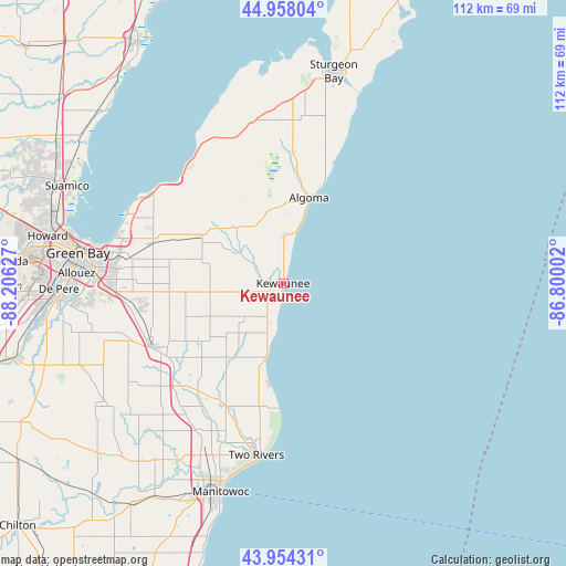
Kewaunee GPS coordinates[2]
44° 27' 29.988" North, 87° 30' 11.304" West
| Map corner | latitude | longitude |
|---|---|---|
| Upper-left | 44.95804°, | -88.20627° |
| Center: | 44.45833°, | -87.50314° |
| Lower-right: | 43.95431°, | -86.80002° |
| Map W x H: | 111.6×111.6 km | = 69.3×69.3mi |
| max Lat: | 71.29058° ⇑9.7% North |
| Kewaunee: | 44.45833° |
| min Lat: | ⇓90.3% South 19.06759° |
| min Long | Kewaunee | max Long |
| -171.73463° | -87.50314° | -66.98998° |
| W 49.2%⇐ | ⇒50.8% E |
Elevation
Elevation of Kewaunee is 185 m = 607 ft, and this is 109.8 m = 360 ft below average elevation for this country.
| Max E: |
3189 m = 10463 ft | 53.6% |
| Avg. | 294.8 m = 967 ft | |
| Kewaunee | 185 m = 607 ft | |
Min E: |
-60 m = -197 ft | 46.4% |
See also: United States elevation on elevation.city.
Geographical zone
Kewaunee is located in North temperate zone (between Tropic of Cancer and the Arctic Circle). Distance of this Northern Tropic circle is 2337.4 km =1452.4 mi to South.| Distance of | km | miles | from Kewaunee |
|---|---|---|---|
| North Pole | 5063.8 | 3146.5 | to North |
| Arctic Circle | 2457.9 | 1527.3 | to North |
| Tropic Cancer | 2337.4 | 1452.4 | to South |
| Equator | 4943.3 | 3071.6 | to South |


Nearby cities:
15 places around Kewaunee: (largest is in red/bold)
• Algoma
17.6 km =10.9 mi,  18°
18°
• Allouez
40.8 km =25.4 mi,  272°
272°
• Bellevue
33.1 km =20.6 mi, 267°
• Brussels
32.3 km =20.1 mi,  343°
343°
• Casco
14.3 km =8.9 mi,  320°
320°
• Cooperstown
27 km =16.8 mi,  233°
233°
• Denmark
28.5 km =17.7 mi,  244°
244°
• Dyckesville
29 km =18 mi, 315°
• Francis Creek
33.6 km =20.9 mi,  211°
211°
• Glenmore
34.6 km =21.5 mi,  256°
256°
• Green Bay
41.5 km =25.8 mi,  279°
279°
• Luxemburg
18.3 km =11.4 mi,  299°
299°
• Manitowoc
42.9 km =26.7 mi,  196°
196°
• Mishicot
26.7 km =16.6 mi, 204°
• Two Rivers
34.3 km =21.3 mi,  188°
188°
Sources, notices
• [Note1] Compared only with cities in United States existing in our database
• [Src1] Map data: © OpenStreetMap contributors (CC-BY-SA)
• [Src2] Other city data from geonames.org with taken over terms of usage.
• [Src3] Geographical zone / Annual Mean Temperature by Robert A. Rohde @ Wikipedia
