Dyckesville geodata
Dyckesville (Wisconsin) is a populated place; located in United States in America/Chicago (GMT-5) time zone. With population of 538 people, there are 20410 cities with bigger population in this country. Compared to other cities in United States, 91.1% of cities are located further ↓South; 51.7% of cities are located further →East and 54.5% of cities have higher elevation than Dyckesville. Note1


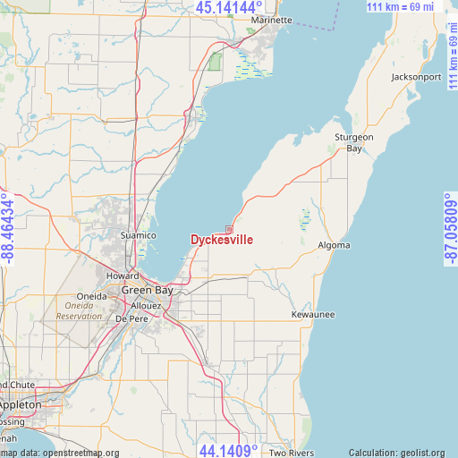
Dyckesville GPS coordinates[2]
44° 38' 35.988" North, 87° 45' 40.356" West
| Map corner | latitude | longitude |
|---|---|---|
| Upper-left | 45.14144°, | -88.46434° |
| Center: | 44.64333°, | -87.76121° |
| Lower-right: | 44.1409°, | -87.05809° |
| Map W x H: | 111.2×111.2 km | = 69.1×69.1mi |
| max Lat: | 71.29058° ⇑8.9% North |
| Dyckesville: | 44.64333° |
| min Lat: | ⇓91.1% South 19.06759° |
| min Long | Dyckesville | max Long |
| -171.73463° | -87.76121° | -66.98998° |
| W 48.3%⇐ | ⇒51.7% E |
Elevation
Elevation of Dyckesville is 182 m = 597 ft, and this is 112.8 m = 370 ft below average elevation for this country.
| Max E: |
3189 m = 10463 ft | 54.5% |
| Avg. | 294.8 m = 967 ft | |
| Dyckesville | 182 m = 597 ft | |
Min E: |
-60 m = -197 ft | 45.5% |
See also: United States elevation on elevation.city.
Geographical zone
Dyckesville is located in North temperate zone (between Tropic of Cancer and the Arctic Circle). Distance of this Northern Tropic circle is 2358 km =1465.2 mi to South.| Distance of | km | miles | from Dyckesville |
|---|---|---|---|
| North Pole | 5043.2 | 3133.7 | to North |
| Arctic Circle | 2437.3 | 1514.5 | to North |
| Tropic Cancer | 2358 | 1465.2 | to South |
| Equator | 4963.9 | 3084.4 | to South |


Nearby cities:
15 places around Dyckesville: (largest is in red/bold)
• Algoma
26.3 km =16.3 mi,  98°
98°
• Allouez
27.4 km =17 mi,  227°
227°
• Ashwaubenon
30.3 km =18.8 mi, 233°
• Bellevue
25.5 km =15.8 mi,  209°
209°
• Brussels
15.1 km =9.4 mi,  47°
47°
• Casco
14.8 km =9.2 mi,  130°
130°
• De Pere
32.1 km =19.9 mi, 227°
• Denmark
33.3 km =20.7 mi,  189°
189°
• Glenmore
31.5 km =19.6 mi,  204°
204°
• Green Bay
24.7 km =15.3 mi,  236°
236°
• Howard
28.2 km =17.5 mi,  246°
246°
• Kewaunee
29 km =18 mi,  135°
135°
• Luxemburg
12.5 km =7.8 mi,  158°
158°
• Oconto
28.3 km =17.6 mi,  343°
343°
• Suamico
22 km =13.7 mi,  266°
266°
Sources, notices
• [Note1] Compared only with cities in United States existing in our database
• [Src1] Map data: © OpenStreetMap contributors (CC-BY-SA)
• [Src2] Other city data from geonames.org with taken over terms of usage.
• [Src3] Geographical zone / Annual Mean Temperature by Robert A. Rohde @ Wikipedia
