Waukesha geodata
Waukesha (Wisconsin) is a seat of a second-order administrative division; located in United States in America/Chicago (GMT-5) time zone. With population of 71,970 people, there are 572 cities with bigger population in this country. Compared to other cities in United States, 83.4% of cities are located further ↓South; 53.8% of cities are located further →East and 62.8% of cities have lower elevation than Waukesha. Note1


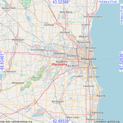
Waukesha GPS coordinates[2]
43° 0' 42.048" North, 88° 13' 53.328" West
| Map corner | latitude | longitude |
|---|---|---|
| Upper-left | 43.52366°, | -88.93461° |
| Center: | 43.01168°, | -88.23148° |
| Lower-right: | 42.49539°, | -87.52836° |
| Map W x H: | 114.3×114.3 km | = 71×71mi |
| max Lat: | 71.29058° ⇑16.6% North |
| Waukesha: | 43.01168° |
| min Lat: | ⇓83.4% South 19.06759° |
| min Long | Waukesha | max Long |
| -171.73463° | -88.23148° | -66.98998° |
| W 46.2%⇐ | ⇒53.8% E |
Elevation
Elevation of Waukesha is 252 m = 827 ft, and this is 42.8 m = 140 ft below average elevation for this country.
| Max E: |
3189 m = 10463 ft | 37.2% |
| Avg. | 294.8 m = 967 ft | |
| Waukesha | 252 m = 827 ft | |
Min E: |
-60 m = -197 ft | 62.8% |
See also: Waukesha elevation on elevation.city.
Geographical zone
Waukesha is located in North temperate zone (between Tropic of Cancer and the Arctic Circle). Distance of this Northern Tropic circle is 2176.5 km =1352.4 mi to South.| Distance of | km | miles | from Waukesha |
|---|---|---|---|
| North Pole | 5224.6 | 3246.4 | to North |
| Arctic Circle | 2618.7 | 1627.2 | to North |
| Tropic Cancer | 2176.5 | 1352.4 | to South |
| Equator | 4782.5 | 2971.7 | to South |


Nearby cities:
15 places around Waukesha: (largest is in red/bold)
• Big Bend
14.6 km =9.1 mi,  172°
172°
• Brookfield
11.5 km =7.1 mi,  61°
61°
• Butler
16.8 km =10.4 mi,  51°
51°
• Delafield
15 km =9.3 mi,  291°
291°
• Elm Grove
12.9 km =8 mi,  74°
74°
• Hartland
13.7 km =8.5 mi,  319°
319°
• Lannon
15.9 km =9.9 mi,  19°
19°
• Merton
16.2 km =10.1 mi,  337°
337°
• Muskego
14 km =8.7 mi,  147°
147°
• Nashotah
16.9 km =10.5 mi,  304°
304°
• New Berlin
10.7 km =6.6 mi,  111°
111°
• North Prairie
16.5 km =10.3 mi,  238°
238°
• Pewaukee
8 km =5 mi, 342°
• Sussex
13.6 km =8.5 mi,  3°
3°
• Wales
11.8 km =7.3 mi,  266°
266°
Sources, notices
• [Note1] Compared only with cities in United States existing in our database
• [Src1] Map data: © OpenStreetMap contributors (CC-BY-SA)
• [Src2] Other city data from geonames.org with taken over terms of usage.
• [Src3] Geographical zone / Annual Mean Temperature by Robert A. Rohde @ Wikipedia
