New Berlin geodata
New Berlin (Wisconsin) is a populated place; located in United States in America/Chicago (GMT-5) time zone. With population of 39,825 people, there are 1215 cities with bigger population in this country. Compared to other cities in United States, 83.1% of cities are located further ↓South; 53.4% of cities are located further →East and 69% of cities have lower elevation than New Berlin. Note1


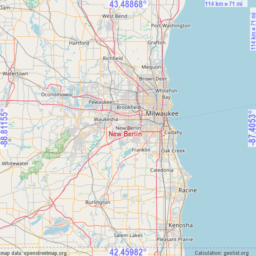
New Berlin GPS coordinates[2]
42° 58' 35.04" North, 88° 6' 30.312" West
| Map corner | latitude | longitude |
|---|---|---|
| Upper-left | 43.48868°, | -88.81155° |
| Center: | 42.9764°, | -88.10842° |
| Lower-right: | 42.45982°, | -87.4053° |
| Map W x H: | 114.4×114.4 km | = 71.1×71.1mi |
| max Lat: | 71.29058° ⇑16.9% North |
| New Berlin: | 42.9764° |
| min Lat: | ⇓83.1% South 19.06759° |
| min Long | New Berlin | max Long |
| -171.73463° | -88.10842° | -66.98998° |
| W 46.6%⇐ | ⇒53.4% E |
Elevation
Elevation of New Berlin is 281 m = 922 ft, and this is 13.8 m = 45 ft below average elevation for this country.
| Max E: |
3189 m = 10463 ft | 31% |
| Avg. | 294.8 m = 967 ft | |
| New Berlin | 281 m = 922 ft | |
Min E: |
-60 m = -197 ft | 69% |
See also: United States elevation on elevation.city.
Geographical zone
New Berlin is located in North temperate zone (between Tropic of Cancer and the Arctic Circle). Distance of this Northern Tropic circle is 2172.6 km =1350 mi to South.| Distance of | km | miles | from New Berlin |
|---|---|---|---|
| North Pole | 5228.5 | 3248.8 | to North |
| Arctic Circle | 2622.6 | 1629.6 | to North |
| Tropic Cancer | 2172.6 | 1350 | to South |
| Equator | 4778.5 | 2969.2 | to South |


Nearby cities:
15 places around New Berlin: (largest is in red/bold)
• Big Bend
13.3 km =8.3 mi,  217°
217°
• Brookfield
9.4 km =5.8 mi,  0°
0°
• Butler
14.7 km =9.1 mi,  12°
12°
• Elm Grove
7.8 km =4.8 mi,  17°
17°
• Franklin
11.3 km =7 mi,  149°
149°
• Greendale
10 km =6.2 mi,  113°
113°
• Greenfield
8 km =5 mi,  102°
102°
• Hales Corners
6.5 km =4 mi,  131°
131°
• Muskego
8.2 km =5.1 mi,  197°
197°
• Pewaukee
17 km =10.6 mi,  313°
313°
• Waukesha
10.7 km =6.6 mi,  291°
291°
• Wauwatosa
11.5 km =7.1 mi,  45°
45°
• West Allis
9.4 km =5.8 mi,  61°
61°
• West Milwaukee
11.8 km =7.3 mi,  70°
70°
• Wind Lake
16.8 km =10.4 mi,  194°
194°
Sources, notices
• [Note1] Compared only with cities in United States existing in our database
• [Src1] Map data: © OpenStreetMap contributors (CC-BY-SA)
• [Src2] Other city data from geonames.org with taken over terms of usage.
• [Src3] Geographical zone / Annual Mean Temperature by Robert A. Rohde @ Wikipedia
