Whitefish Bay geodata
Whitefish Bay (Wisconsin) is a populated place; located in United States in America/Chicago (GMT-5) time zone. With population of 14,110 people, there are 3412 cities with bigger population in this country. Compared to other cities in United States, 84.2% of cities are located further ↓South; 52.4% of cities are located further →East and 51.2% of cities have lower elevation than Whitefish Bay. Note1
Administrative division(s):
- Level 1: Wisconsin
- Level 2: Milwaukee County
- Level 3: Village of Whitefish Bay


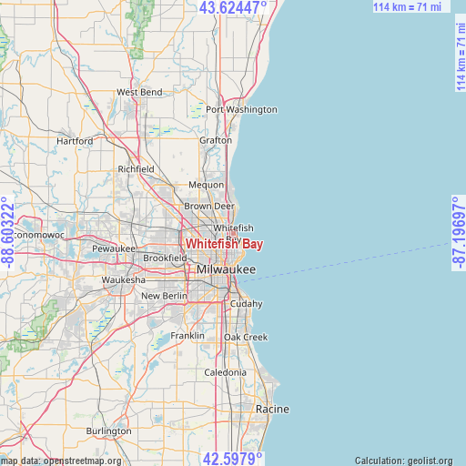
Whitefish Bay GPS coordinates[2]
43° 6' 48.024" North, 87° 54' 0.324" West
| Map corner | latitude | longitude |
|---|---|---|
| Upper-left | 43.62447°, | -88.60322° |
| Center: | 43.11334°, | -87.90009° |
| Lower-right: | 42.5979°, | -87.19697° |
| Map W x H: | 114.1×114.1 km | = 70.9×70.9mi |
| max Lat: | 71.29058° ⇑15.8% North |
| Whitefish Bay: | 43.11334° |
| min Lat: | ⇓84.2% South 19.06759° |
| min Long | Whitefish Bay | max Long |
| -171.73463° | -87.90009° | -66.98998° |
| W 47.6%⇐ | ⇒52.4% E |
Elevation
Elevation of Whitefish Bay is 203 m = 666 ft, and this is 91.8 m = 301 ft below average elevation for this country.
| Max E: |
3189 m = 10463 ft | 48.8% |
| Avg. | 294.8 m = 967 ft | |
| Whitefish Bay | 203 m = 666 ft | |
Min E: |
-60 m = -197 ft | 51.2% |
See also: United States elevation on elevation.city.
Geographical zone
Whitefish Bay is located in North temperate zone (between Tropic of Cancer and the Arctic Circle). Distance of this Northern Tropic circle is 2187.8 km =1359.4 mi to South.| Distance of | km | miles | from Whitefish Bay |
|---|---|---|---|
| North Pole | 5213.3 | 3239.4 | to North |
| Arctic Circle | 2607.4 | 1620.2 | to North |
| Tropic Cancer | 2187.8 | 1359.4 | to South |
| Equator | 4793.8 | 2978.7 | to South |


Nearby cities:
15 places around Whitefish Bay: (largest is in red/bold)
• Bayside
7.5 km =4.7 mi,  359°
359°
• Brown Deer
7.6 km =4.7 mi,  316°
316°
• Butler
13.8 km =8.6 mi,  266°
266°
• Elm Grove
16.5 km =10.3 mi,  241°
241°
• Fox Point
4.9 km =3 mi, 358°
• Glendale
3.8 km =2.4 mi,  310°
310°
• Mequon
15.5 km =9.6 mi, 317°
• Milwaukee
8.3 km =5.2 mi,  183°
183°
• River Hills
7 km =4.3 mi,  343°
343°
• Saint Francis
16.3 km =10.1 mi,  173°
173°
• Shorewood
2.9 km =1.8 mi,  159°
159°
• Thiensville
15.2 km =9.4 mi, 335°
• Wauwatosa
11.3 km =7 mi,  230°
230°
• West Allis
13.8 km =8.6 mi,  218°
218°
• West Milwaukee
12.7 km =7.9 mi,  207°
207°
Sources, notices
• [Note1] Compared only with cities in United States existing in our database
• [Src1] Map data: © OpenStreetMap contributors (CC-BY-SA)
• [Src2] Other city data from geonames.org with taken over terms of usage.
• [Src3] Geographical zone / Annual Mean Temperature by Robert A. Rohde @ Wikipedia
