Holbrook geodata
Holbrook (Arizona) is a seat of a second-order administrative division; located in United States in America/Phoenix (GMT-7) time zone. With population of 5,019 people, there are 7153 cities with bigger population in this country. Compared to other cities in United States, 75.9% of cities are located further ↑North; 85.8% of cities are located further →East and 97.1% of cities have lower elevation than Holbrook. Note1


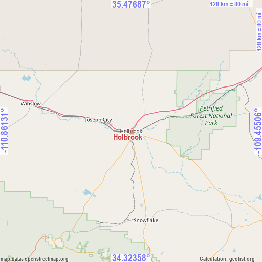
Holbrook GPS coordinates[2]
34° 54' 8.1" North, 110° 9' 29.448" West
| Map corner | latitude | longitude |
|---|---|---|
| Upper-left | 35.47687°, | -110.86131° |
| Center: | 34.90225°, | -110.15818° |
| Lower-right: | 34.32358°, | -109.45506° |
| Map W x H: | 128.2×128.2 km | = 79.7×79.7mi |
| max Lat: | 71.29058° ⇑75.9% North |
| Holbrook: | 34.90225° |
| min Lat: | ⇓24.1% South 19.06759° |
| min Long | Holbrook | max Long |
| -171.73463° | -110.15818° | -66.98998° |
| W 14.2%⇐ | ⇒85.8% E |
Elevation
Elevation of Holbrook is 1550 m = 5085 ft, and this is 1255.2 m = 4118 ft above average elevation for this country.
| Max E: |
3189 m = 10463 ft | 2.9% |
| Holbrook | 1550 m 5085 ft | |
| Avg. | 294.8 m = 967 ft | |
Min E: |
-60 m = -197 ft | 97.1% |
See also: United States elevation on elevation.city.
Geographical zone
Holbrook is located in North temperate zone (between Tropic of Cancer and the Arctic Circle). Distance of this Northern Tropic circle is 1274.8 km =792.1 mi to South.| Distance of | km | miles | from Holbrook |
|---|---|---|---|
| North Pole | 6126.3 | 3806.7 | to North |
| Arctic Circle | 3520.4 | 2187.5 | to North |
| Tropic Cancer | 1274.8 | 792.1 | to South |
| Equator | 3880.8 | 2411.4 | to South |


Nearby cities:
15 places around Holbrook: (largest is in red/bold)
• Dilkon
55.7 km =34.6 mi,  344°
344°
• Greasewood
74.2 km =46.1 mi,  21°
21°
• Heber-Overgaard
66 km =41 mi,  214°
214°
• Joseph City
17.1 km =10.6 mi,  290°
290°
• Lake of the Woods
83.5 km =51.9 mi,  169°
169°
• LeChee
56.1 km =34.9 mi,  284°
284°
• Linden
68.6 km =42.6 mi,  179°
179°
• Saint Johns
85.2 km =52.9 mi,  121°
121°
• Sanders
82.8 km =51.4 mi,  65°
65°
• Show Low
73 km =45.4 mi, 170°
• Snowflake
43.8 km =27.2 mi, 170°
• Taylor
49 km =30.4 mi, 172°
• White Cone
78.6 km =48.8 mi,  5°
5°
• White Mountain Lake
63.3 km =39.3 mi, 166°
• Winslow
51 km =31.7 mi, 285°
Sources, notices
• [Note1] Compared only with cities in United States existing in our database
• [Src1] Map data: © OpenStreetMap contributors (CC-BY-SA)
• [Src2] Other city data from geonames.org with taken over terms of usage.
• [Src3] Geographical zone / Annual Mean Temperature by Robert A. Rohde @ Wikipedia
