Winslow geodata
Winslow (Arizona) is a populated place; located in United States in America/Phoenix (GMT-7) time zone. With population of 9,600 people, there are 4588 cities with bigger population in this country. Compared to other cities in United States, 75.3% of cities are located further ↑North; 86% of cities are located further →East and 96.5% of cities have lower elevation than Winslow. Note1


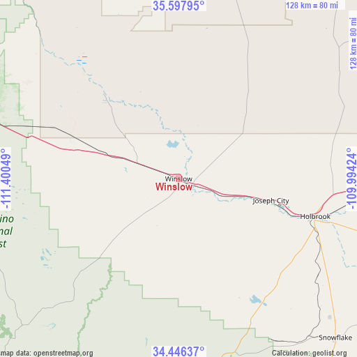
Winslow GPS coordinates[2]
35° 1' 27.084" North, 110° 41' 50.496" West
| Map corner | latitude | longitude |
|---|---|---|
| Upper-left | 35.59795°, | -111.40049° |
| Center: | 35.02419°, | -110.69736° |
| Lower-right: | 34.44637°, | -109.99424° |
| Map W x H: | 128×128 km | = 79.5×79.5mi |
| max Lat: | 71.29058° ⇑75.3% North |
| Winslow: | 35.02419° |
| min Lat: | ⇓24.7% South 19.06759° |
| min Long | Winslow | max Long |
| -171.73463° | -110.69736° | -66.98998° |
| W 14%⇐ | ⇒86% E |
Elevation
Elevation of Winslow is 1480 m = 4856 ft, and this is 1185.2 m = 3888 ft above average elevation for this country.
| Max E: |
3189 m = 10463 ft | 3.5% |
| Winslow | 1480 m 4856 ft | |
| Avg. | 294.8 m = 967 ft | |
Min E: |
-60 m = -197 ft | 96.5% |
See also: United States elevation on elevation.city.
Geographical zone
Winslow is located in North temperate zone (between Tropic of Cancer and the Arctic Circle). Distance of this Northern Tropic circle is 1288.4 km =800.6 mi to South.| Distance of | km | miles | from Winslow |
|---|---|---|---|
| North Pole | 6112.7 | 3798.3 | to North |
| Arctic Circle | 3506.8 | 2179 | to North |
| Tropic Cancer | 1288.4 | 800.6 | to South |
| Equator | 3894.3 | 2419.8 | to South |


Nearby cities:
15 places around Winslow: (largest is in red/bold)
• Dilkon
52.8 km =32.8 mi,  40°
40°
• Flagstaff
88.9 km =55.2 mi,  282°
282°
• Heber-Overgaard
68.8 km =42.8 mi,  170°
170°
• Holbrook
51 km =31.7 mi,  105°
105°
• Joseph City
34 km =21.1 mi,  102°
102°
• LeChee
5.1 km =3.2 mi, 280°
• Leupp
41.4 km =25.7 mi,  317°
317°
• Mountainaire
88.4 km =54.9 mi,  274°
274°
• Munds Park
86.3 km =53.6 mi,  264°
264°
• Second Mesa
87.3 km =54.2 mi,  11°
11°
• Shongopovi
89.5 km =55.6 mi, 9°
• Shungopavi
88.2 km =54.8 mi, 10°
• Snowflake
80.1 km =49.8 mi,  135°
135°
• Taylor
83.3 km =51.8 mi, 138°
• White Cone
86.2 km =53.6 mi, 41°
Sources, notices
• [Note1] Compared only with cities in United States existing in our database
• [Src1] Map data: © OpenStreetMap contributors (CC-BY-SA)
• [Src2] Other city data from geonames.org with taken over terms of usage.
• [Src3] Geographical zone / Annual Mean Temperature by Robert A. Rohde @ Wikipedia
