Desert Hills geodata
Desert Hills (Arizona) is a populated place; located in United States in America/Phoenix (GMT-7) time zone. With population of 2,245 people, there are 11229 cities with bigger population in this country. Compared to other cities in United States, 77.4% of cities are located further ↑North; 88.7% of cities are located further →East and 57.5% of cities have higher elevation than Desert Hills. Note1


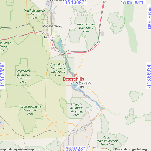
Desert Hills GPS coordinates[2]
34° 33' 14.04" North, 114° 22' 20.856" West
| Map corner | latitude | longitude |
|---|---|---|
| Upper-left | 35.13097°, | -115.07559° |
| Center: | 34.5539°, | -114.37246° |
| Lower-right: | 33.9728°, | -113.66934° |
| Map W x H: | 128.8×128.8 km | = 80×80mi |
| max Lat: | 71.29058° ⇑77.4% North |
| Desert Hills: | 34.5539° |
| min Lat: | ⇓22.6% South 19.06759° |
| min Long | Desert Hills | max Long |
| -171.73463° | -114.37246° | -66.98998° |
| W 11.3%⇐ | ⇒88.7% E |
Elevation
Elevation of Desert Hills is 168 m = 551 ft, and this is 126.8 m = 416 ft below average elevation for this country.
| Max E: |
3189 m = 10463 ft | 57.5% |
| Avg. | 294.8 m = 967 ft | |
| Desert Hills | 168 m = 551 ft | |
Min E: |
-60 m = -197 ft | 42.5% |
See also: United States elevation on elevation.city.
Geographical zone
Desert Hills is located in North temperate zone (between Tropic of Cancer and the Arctic Circle). Distance of this Northern Tropic circle is 1236.1 km =768.1 mi to South.| Distance of | km | miles | from Desert Hills |
|---|---|---|---|
| North Pole | 6165 | 3830.8 | to North |
| Arctic Circle | 3559.1 | 2211.5 | to North |
| Tropic Cancer | 1236.1 | 768.1 | to South |
| Equator | 3842 | 2387.3 | to South |


Nearby cities:
15 places around Desert Hills: (largest is in red/bold)
• Arizona Village
38.5 km =23.9 mi,  329°
329°
• Big River
46 km =28.6 mi,  178°
178°
• Bluewater
44 km =27.3 mi,  167°
167°
• Bullhead City
68.4 km =42.5 mi,  344°
344°
• Cienega Springs
42.8 km =26.6 mi,  161°
161°
• Golden Shores
27.1 km =16.8 mi, 339°
• Golden Valley
75.7 km =47 mi,  10°
10°
• Lake Havasu City
9 km =5.6 mi,  149°
149°
• Laughlin
70.7 km =43.9 mi, 344°
• Mohave Valley
46.6 km =29 mi, 334°
• Needles
39.5 km =24.5 mi, 325°
• Parker
45.6 km =28.3 mi, 170°
• Parker Strip
40.5 km =25.2 mi, 156°
• Walnut Creek
68 km =42.3 mi,  19°
19°
• Willow Valley
45.2 km =28.1 mi, 331°
Sources, notices
• [Note1] Compared only with cities in United States existing in our database
• [Src1] Map data: © OpenStreetMap contributors (CC-BY-SA)
• [Src2] Other city data from geonames.org with taken over terms of usage.
• [Src3] Geographical zone / Annual Mean Temperature by Robert A. Rohde @ Wikipedia
