Mohave Valley geodata
Mohave Valley (Arizona) is a populated place; located in United States in America/Phoenix (GMT-7) time zone. With population of 2,616 people, there are 10362 cities with bigger population in this country. Compared to other cities in United States, 75.8% of cities are located further ↑North; 88.8% of cities are located further →East and 62.1% of cities have higher elevation than Mohave Valley. Note1


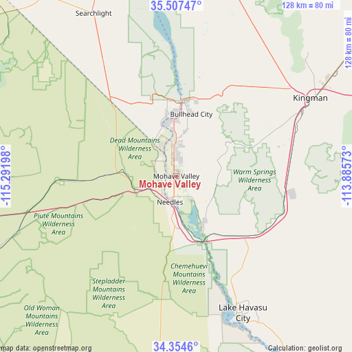
Mohave Valley GPS coordinates[2]
34° 55' 59.016" North, 114° 35' 19.86" West
| Map corner | latitude | longitude |
|---|---|---|
| Upper-left | 35.50747°, | -115.29198° |
| Center: | 34.93306°, | -114.58885° |
| Lower-right: | 34.3546°, | -113.88573° |
| Map W x H: | 128.2×128.2 km | = 79.7×79.7mi |
| max Lat: | 71.29058° ⇑75.8% North |
| Mohave Valley: | 34.93306° |
| min Lat: | ⇓24.2% South 19.06759° |
| min Long | Mohave Valley | max Long |
| -171.73463° | -114.58885° | -66.98998° |
| W 11.2%⇐ | ⇒88.8% E |
Elevation
Elevation of Mohave Valley is 144 m = 472 ft, and this is 150.8 m = 495 ft below average elevation for this country.
| Max E: |
3189 m = 10463 ft | 62.1% |
| Avg. | 294.8 m = 967 ft | |
| Mohave Valley | 144 m = 472 ft | |
Min E: |
-60 m = -197 ft | 37.9% |
See also: United States elevation on elevation.city.
Geographical zone
Mohave Valley is located in North temperate zone (between Tropic of Cancer and the Arctic Circle). Distance of this Northern Tropic circle is 1278.3 km =794.3 mi to South.| Distance of | km | miles | from Mohave Valley |
|---|---|---|---|
| North Pole | 6122.9 | 3804.6 | to North |
| Arctic Circle | 3517 | 2185.4 | to North |
| Tropic Cancer | 1278.3 | 794.3 | to South |
| Equator | 3884.2 | 2413.5 | to South |


Nearby cities:
15 places around Mohave Valley: (largest is in red/bold)
• Arizona Village
8.9 km =5.5 mi,  177°
177°
• Bullhead City
23.9 km =14.9 mi,  4°
4°
• Desert Hills
46.6 km =29 mi,  154°
154°
• Dolan Springs
78.7 km =48.9 mi,  21°
21°
• Golden Shores
19.6 km =12.2 mi, 148°
• Golden Valley
46.4 km =28.8 mi,  45°
45°
• Kingman
56.5 km =35.1 mi,  59°
59°
• Lake Havasu City
55.6 km =34.5 mi, 154°
• Laughlin
26.1 km =16.2 mi, 3°
• Needles
9.7 km =6 mi,  193°
193°
• New Kingman-Butler
62.7 km =39 mi, 53°
• Searchlight
66.4 km =41.3 mi,  333°
333°
• Valle Vista
84.7 km =52.6 mi, 51°
• Walnut Creek
47.5 km =29.5 mi, 62°
• Willow Valley
2.9 km =1.8 mi,  214°
214°
Sources, notices
• [Note1] Compared only with cities in United States existing in our database
• [Src1] Map data: © OpenStreetMap contributors (CC-BY-SA)
• [Src2] Other city data from geonames.org with taken over terms of usage.
• [Src3] Geographical zone / Annual Mean Temperature by Robert A. Rohde @ Wikipedia
