Lake Havasu City geodata
Lake Havasu City (Arizona) is a populated place; located in United States in America/Phoenix (GMT-7) time zone. With population of 53,553 people, there are 872 cities with bigger population in this country. Compared to other cities in United States, 77.8% of cities are located further ↑North; 88.7% of cities are located further →East and 57.5% of cities have lower elevation than Lake Havasu City. Note1


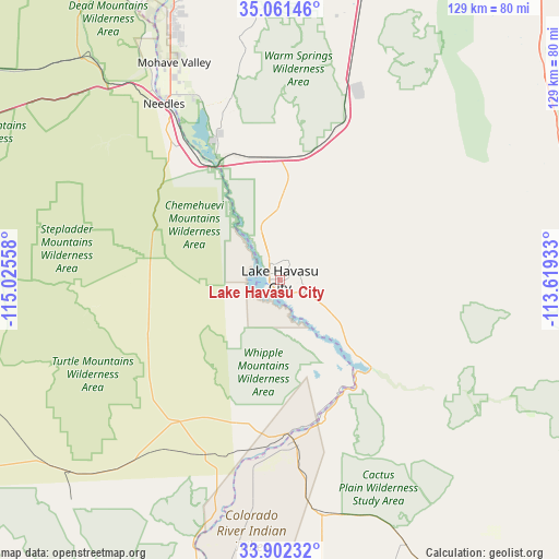
Lake Havasu City GPS coordinates[2]
34° 29' 2.04" North, 114° 19' 20.82" West
| Map corner | latitude | longitude |
|---|---|---|
| Upper-left | 35.06146°, | -115.02558° |
| Center: | 34.4839°, | -114.32245° |
| Lower-right: | 33.90232°, | -113.61933° |
| Map W x H: | 128.9×128.9 km | = 80.1×80.1mi |
| max Lat: | 71.29058° ⇑77.8% North |
| Lake Havasu City: | 34.4839° |
| min Lat: | ⇓22.2% South 19.06759° |
| min Long | Lake Havasu Cit | max Long |
| -171.73463° | -114.32245° | -66.98998° |
| W 11.3%⇐ | ⇒88.7% E |
Elevation
Elevation of Lake Havasu City is 228 m = 748 ft, and this is 66.8 m = 219 ft below average elevation for this country.
| Max E: |
3189 m = 10463 ft | 42.5% |
| Avg. | 294.8 m = 967 ft | |
| Lake Havasu City | 228 m = 748 ft | |
Min E: |
-60 m = -197 ft | 57.5% |
See also: Lake Havasu City elevation on elevation.city.
Geographical zone
Lake Havasu City is located in North temperate zone (between Tropic of Cancer and the Arctic Circle). Distance of this Northern Tropic circle is 1228.3 km =763.2 mi to South.| Distance of | km | miles | from Lake Havasu City |
|---|---|---|---|
| North Pole | 6172.8 | 3835.6 | to North |
| Arctic Circle | 3566.9 | 2216.4 | to North |
| Tropic Cancer | 1228.3 | 763.2 | to South |
| Equator | 3834.3 | 2382.5 | to South |


Nearby cities:
15 places around Lake Havasu City: (largest is in red/bold)
• Arizona Village
47.5 km =29.5 mi,  329°
329°
• Big River
38.4 km =23.9 mi,  185°
185°
• Bluewater
35.5 km =22.1 mi,  171°
171°
• Bouse
67.9 km =42.2 mi,  154°
154°
• Bullhead City
77.2 km =48 mi,  343°
343°
• Cienega Springs
34 km =21.1 mi,  164°
164°
• Desert Hills
9 km =5.6 mi, 329°
• Golden Shores
36.1 km =22.4 mi, 336°
• Laughlin
79.4 km =49.3 mi, 343°
• Mohave Valley
55.6 km =34.5 mi, 334°
• Needles
48.5 km =30.1 mi, 326°
• Parker
37.2 km =23.1 mi,  175°
175°
• Parker Strip
31.5 km =19.6 mi, 158°
• Walnut Creek
74.2 km =46.1 mi,  13°
13°
• Willow Valley
54.2 km =33.7 mi, 331°
Sources, notices
• [Note1] Compared only with cities in United States existing in our database
• [Src1] Map data: © OpenStreetMap contributors (CC-BY-SA)
• [Src2] Other city data from geonames.org with taken over terms of usage.
• [Src3] Geographical zone / Annual Mean Temperature by Robert A. Rohde @ Wikipedia
