Marana geodata
Marana (Arizona) is a populated place; located in United States in America/Phoenix (GMT-7) time zone. With population of 41,315 people, there are 1160 cities with bigger population in this country. Compared to other cities in United States, 87.4% of cities are located further ↑North; 86.4% of cities are located further →East and 89.7% of cities have lower elevation than Marana. Note1


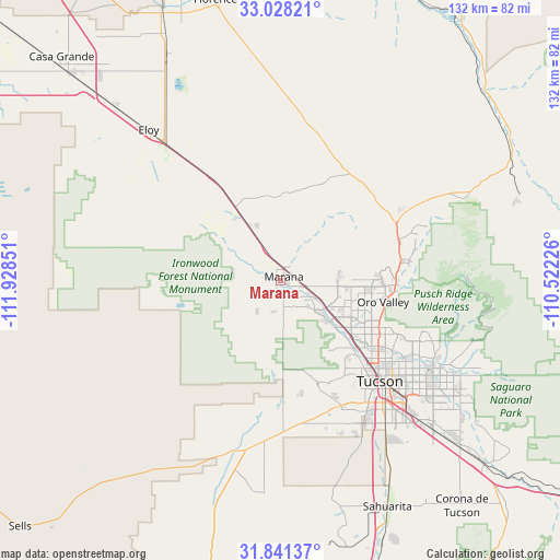
Marana GPS coordinates[2]
32° 26' 12.264" North, 111° 13' 31.368" West
| Map corner | latitude | longitude |
|---|---|---|
| Upper-left | 33.02821°, | -111.92851° |
| Center: | 32.43674°, | -111.22538° |
| Lower-right: | 31.84137°, | -110.52226° |
| Map W x H: | 132×132 km | = 82×82mi |
| max Lat: | 71.29058° ⇑87.4% North |
| Marana: | 32.43674° |
| min Lat: | ⇓12.6% South 19.06759° |
| min Long | Marana | max Long |
| -171.73463° | -111.22538° | -66.98998° |
| W 13.6%⇐ | ⇒86.4% E |
Elevation
Elevation of Marana is 603 m = 1978 ft, and this is 308.2 m = 1011 ft above average elevation for this country.
| Max E: |
3189 m = 10463 ft | 10.3% |
| Marana | 603 m 1978 ft | |
| Avg. | 294.8 m = 967 ft | |
Min E: |
-60 m = -197 ft | 89.7% |
See also: Marana elevation on elevation.city.
Geographical zone
Marana is located in North temperate zone (between Tropic of Cancer and the Arctic Circle). Distance of this Northern Tropic circle is 1000.7 km =621.8 mi to South.| Distance of | km | miles | from Marana |
|---|---|---|---|
| North Pole | 6400.4 | 3977 | to North |
| Arctic Circle | 3794.5 | 2357.8 | to North |
| Tropic Cancer | 1000.7 | 621.8 | to South |
| Equator | 3606.6 | 2241 | to South |


Nearby cities:
15 places around Marana: (largest is in red/bold)
• Avra Valley
8.4 km =5.2 mi,  270°
270°
• Casas Adobes
25 km =15.5 mi,  120°
120°
• Catalina
29.6 km =18.4 mi,  74°
74°
• Catalina Foothills
32.7 km =20.3 mi, 118°
• Drexel Heights
37.7 km =23.4 mi,  150°
150°
• Flowing Wells
25.7 km =16 mi,  128°
128°
• Oro Valley
24.8 km =15.4 mi,  101°
101°
• Picture Rocks
10.3 km =6.4 mi,  190°
190°
• Saddle Brooke
34.7 km =21.6 mi, 71°
• South Tucson
35.8 km =22.2 mi,  137°
137°
• Three Points
40.9 km =25.4 mi, 191°
• Tortolita
19.7 km =12.2 mi, 98°
• Tucson
36.9 km =22.9 mi, 130°
• Tucson Estates
30.4 km =18.9 mi,  155°
155°
• Valencia West
35.4 km =22 mi, 162°
Sources, notices
• [Note1] Compared only with cities in United States existing in our database
• [Src1] Map data: © OpenStreetMap contributors (CC-BY-SA)
• [Src2] Other city data from geonames.org with taken over terms of usage.
• [Src3] Geographical zone / Annual Mean Temperature by Robert A. Rohde @ Wikipedia
