Naco geodata
Naco (Arizona) is a populated place; located in United States in America/Phoenix (GMT-7) time zone. With population of 1,046 people, there are 15992 cities with bigger population in this country. Compared to other cities in United States, 90% of cities are located further ↑North; 85.7% of cities are located further →East and 96.1% of cities have lower elevation than Naco. Note1


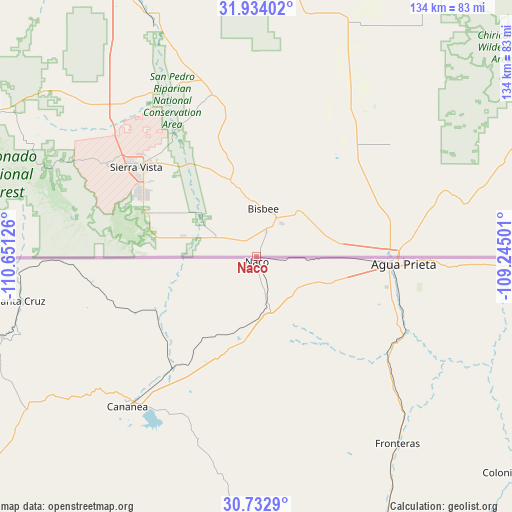
Naco GPS coordinates[2]
31° 20' 7.368" North, 109° 56' 53.268" West
| Map corner | latitude | longitude |
|---|---|---|
| Upper-left | 31.93402°, | -110.65126° |
| Center: | 31.33538°, | -109.94813° |
| Lower-right: | 30.7329°, | -109.24501° |
| Map W x H: | 133.6×133.6 km | = 83×83mi |
| max Lat: | 71.29058° ⇑90% North |
| Naco: | 31.33538° |
| min Lat: | ⇓10% South 19.06759° |
| min Long | Naco | max Long |
| -171.73463° | -109.94813° | -66.98998° |
| W 14.3%⇐ | ⇒85.7% E |
Elevation
Elevation of Naco is 1410 m = 4626 ft, and this is 1115.2 m = 3659 ft above average elevation for this country.
| Max E: |
3189 m = 10463 ft | 3.9% |
| Naco | 1410 m 4626 ft | |
| Avg. | 294.8 m = 967 ft | |
Min E: |
-60 m = -197 ft | 96.1% |
See also: United States elevation on elevation.city.
Geographical zone
Naco is located in North temperate zone (between Tropic of Cancer and the Arctic Circle). Distance of this Northern Tropic circle is 878.2 km =545.7 mi to South.| Distance of | km | miles | from Naco |
|---|---|---|---|
| North Pole | 6522.9 | 4053.1 | to North |
| Arctic Circle | 3917 | 2433.9 | to North |
| Tropic Cancer | 878.2 | 545.7 | to South |
| Equator | 3484.2 | 2165 | to South |


Nearby cities:
15 places around Naco: (largest is in red/bold)
• Benson
77.6 km =48.2 mi,  335°
335°
• Bisbee
12.7 km =7.9 mi,  8°
8°
• Douglas
38.3 km =23.8 mi,  88°
88°
• Huachuca City
49 km =30.4 mi,  311°
311°
• Miracle Valley
20.1 km =12.5 mi,  284°
284°
• Patagonia
80 km =49.7 mi,  286°
286°
• Pimaco Two
83.4 km =51.8 mi,  325°
325°
• Pirtleville
36.6 km =22.7 mi, 86°
• Saint David
68.1 km =42.3 mi, 338°
• Sierra Vista
41.6 km =25.8 mi, 305°
• Sierra Vista Southeast
28.7 km =17.8 mi,  297°
297°
• Sonoita
77.3 km =48 mi, 299°
• Tombstone
43.5 km =27 mi, 344°
• Whetstone
55.1 km =34.2 mi,  317°
317°
• Whetstone
78.6 km =48.8 mi, 331°
Sources, notices
• [Note1] Compared only with cities in United States existing in our database
• [Src1] Map data: © OpenStreetMap contributors (CC-BY-SA)
• [Src2] Other city data from geonames.org with taken over terms of usage.
• [Src3] Geographical zone / Annual Mean Temperature by Robert A. Rohde @ Wikipedia
