Pirtleville geodata
Pirtleville (Arizona) is a populated place; located in United States in America/Phoenix (GMT-7) time zone. With population of 1,744 people, there are 12756 cities with bigger population in this country. Compared to other cities in United States, 89.9% of cities are located further ↑North; 85.6% of cities are located further →East and 94.6% of cities have lower elevation than Pirtleville. Note1


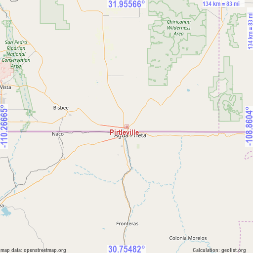
Pirtleville GPS coordinates[2]
31° 21' 25.776" North, 109° 33' 48.672" West
| Map corner | latitude | longitude |
|---|---|---|
| Upper-left | 31.95566°, | -110.26665° |
| Center: | 31.35716°, | -109.56352° |
| Lower-right: | 30.75482°, | -108.8604° |
| Map W x H: | 133.5×133.5 km | = 83×83mi |
| max Lat: | 71.29058° ⇑89.9% North |
| Pirtleville: | 31.35716° |
| min Lat: | ⇓10.1% South 19.06759° |
| min Long | Pirtleville | max Long |
| -171.73463° | -109.56352° | -66.98998° |
| W 14.4%⇐ | ⇒85.6% E |
Elevation
Elevation of Pirtleville is 1213 m = 3980 ft, and this is 918.2 m = 3012 ft above average elevation for this country.
| Max E: |
3189 m = 10463 ft | 5.4% |
| Pirtleville | 1213 m 3980 ft | |
| Avg. | 294.8 m = 967 ft | |
Min E: |
-60 m = -197 ft | 94.6% |
See also: United States elevation on elevation.city.
Geographical zone
Pirtleville is located in North temperate zone (between Tropic of Cancer and the Arctic Circle). Distance of this Northern Tropic circle is 880.7 km =547.2 mi to South.| Distance of | km | miles | from Pirtleville |
|---|---|---|---|
| North Pole | 6520.5 | 4051.6 | to North |
| Arctic Circle | 3914.6 | 2432.4 | to North |
| Tropic Cancer | 880.7 | 547.2 | to South |
| Equator | 3486.6 | 2166.5 | to South |


Nearby cities:
15 places around Pirtleville: (largest is in red/bold)
• Benson
96.9 km =60.2 mi,  314°
314°
• Bisbee
36.1 km =22.4 mi,  286°
286°
• Douglas
2.2 km =1.4 mi,  129°
129°
• Huachuca City
79 km =49.1 mi, 292°
• Mescal
108.4 km =67.4 mi, 310°
• Miracle Valley
56.1 km =34.9 mi,  272°
272°
• Naco
36.6 km =22.7 mi, 266°
• Pimaco Two
106.9 km =66.4 mi, 308°
• Saint David
86.6 km =53.8 mi, 314°
• Sierra Vista
73.6 km =45.7 mi, 287°
• Sierra Vista Southeast
62.9 km =39.1 mi,  279°
279°
• Tombstone
62 km =38.5 mi, 309°
• Whetstone
82.9 km =51.5 mi,  297°
297°
• Whetstone
99.4 km =61.8 mi, 312°
• Willcox
102.8 km =63.9 mi,  345°
345°
Sources, notices
• [Note1] Compared only with cities in United States existing in our database
• [Src1] Map data: © OpenStreetMap contributors (CC-BY-SA)
• [Src2] Other city data from geonames.org with taken over terms of usage.
• [Src3] Geographical zone / Annual Mean Temperature by Robert A. Rohde @ Wikipedia
