Oracle geodata
Oracle (Arizona) is a populated place; located in United States in America/Phoenix (GMT-7) time zone. With population of 3,686 people, there are 8612 cities with bigger population in this country. Compared to other cities in United States, 86.7% of cities are located further ↑North; 86.1% of cities are located further →East and 95.8% of cities have lower elevation than Oracle. Note1


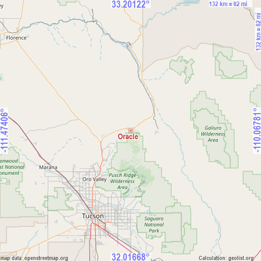
Oracle GPS coordinates[2]
32° 36' 39.276" North, 110° 46' 15.348" West
| Map corner | latitude | longitude |
|---|---|---|
| Upper-left | 33.20122°, | -111.47406° |
| Center: | 32.61091°, | -110.77093° |
| Lower-right: | 32.01668°, | -110.06781° |
| Map W x H: | 131.7×131.7 km | = 81.8×81.8mi |
| max Lat: | 71.29058° ⇑86.7% North |
| Oracle: | 32.61091° |
| min Lat: | ⇓13.3% South 19.06759° |
| min Long | Oracle | max Long |
| -171.73463° | -110.77093° | -66.98998° |
| W 13.9%⇐ | ⇒86.1% E |
Elevation
Elevation of Oracle is 1379 m = 4524 ft, and this is 1084.2 m = 3557 ft above average elevation for this country.
| Max E: |
3189 m = 10463 ft | 4.2% |
| Oracle | 1379 m 4524 ft | |
| Avg. | 294.8 m = 967 ft | |
Min E: |
-60 m = -197 ft | 95.8% |
See also: United States elevation on elevation.city.
Geographical zone
Oracle is located in North temperate zone (between Tropic of Cancer and the Arctic Circle). Distance of this Northern Tropic circle is 1020.1 km =633.9 mi to South.| Distance of | km | miles | from Oracle |
|---|---|---|---|
| North Pole | 6381.1 | 3965 | to North |
| Arctic Circle | 3775.2 | 2345.8 | to North |
| Tropic Cancer | 1020.1 | 633.9 | to South |
| Equator | 3626 | 2253.1 | to South |


Nearby cities:
15 places around Oracle: (largest is in red/bold)
• Casas Adobes
38.3 km =23.8 mi,  213°
213°
• Catalina
18.3 km =11.4 mi,  230°
230°
• Catalina Foothills
37.5 km =23.3 mi,  201°
201°
• Dudleyville
40.2 km =25 mi,  359°
359°
• Flowing Wells
41.8 km =26 mi, 212°
• Hayden
43.8 km =27.2 mi, 358°
• Mammoth
17.4 km =10.8 mi,  44°
44°
• Marana
46.8 km =29.1 mi,  245°
245°
• Oro Valley
30.6 km =19 mi,  216°
216°
• Saddle Brooke
12.8 km =8 mi, 228°
• San Manuel
13.2 km =8.2 mi,  95°
95°
• South Tucson
49.4 km =30.7 mi, 202°
• Tanque Verde
40.1 km =24.9 mi,  175°
175°
• Tortolita
32.1 km =19.9 mi, 226°
• Tucson
45.7 km =28.4 mi, 198°
Sources, notices
• [Note1] Compared only with cities in United States existing in our database
• [Src1] Map data: © OpenStreetMap contributors (CC-BY-SA)
• [Src2] Other city data from geonames.org with taken over terms of usage.
• [Src3] Geographical zone / Annual Mean Temperature by Robert A. Rohde @ Wikipedia
