Alhambra geodata
Alhambra (California) is a populated place; located in United States in America/Los_Angeles (GMT-7) time zone. With population of 85,551 people, there are 451 cities with bigger population in this country. Compared to other cities in United States, 79.6% of cities are located further ↑North; 91.1% of cities are located further →East and 60.3% of cities have higher elevation than Alhambra. Note1


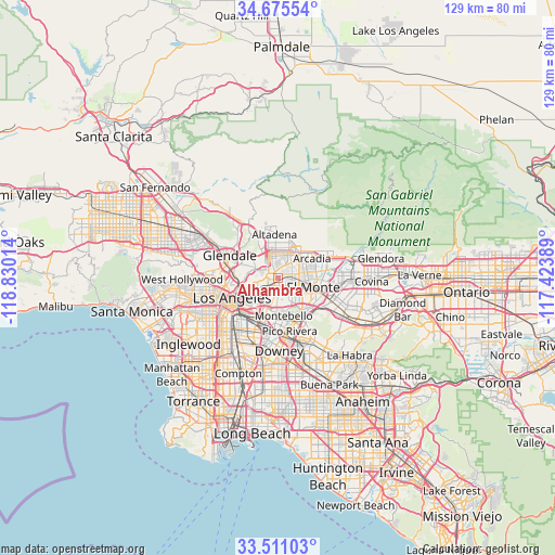
Alhambra GPS coordinates[2]
34° 5' 43.044" North, 118° 7' 37.236" West
| Map corner | latitude | longitude |
|---|---|---|
| Upper-left | 34.67554°, | -118.83014° |
| Center: | 34.09529°, | -118.12701° |
| Lower-right: | 33.51103°, | -117.42389° |
| Map W x H: | 129.5×129.5 km | = 80.5×80.5mi |
| max Lat: | 71.29058° ⇑79.6% North |
| Alhambra: | 34.09529° |
| min Lat: | ⇓20.4% South 19.06759° |
| min Long | Alhambra | max Long |
| -171.73463° | -118.12701° | -66.98998° |
| W 8.9%⇐ | ⇒91.1% E |
Elevation
Elevation of Alhambra is 153 m = 502 ft, and this is 141.8 m = 465 ft below average elevation for this country.
| Max E: |
3189 m = 10463 ft | 60.3% |
| Avg. | 294.8 m = 967 ft | |
| Alhambra | 153 m = 502 ft | |
Min E: |
-60 m = -197 ft | 39.7% |
See also: Alhambra elevation on elevation.city.
Geographical zone
Alhambra is located in North temperate zone (between Tropic of Cancer and the Arctic Circle). Distance of this Northern Tropic circle is 1185.1 km =736.4 mi to South.| Distance of | km | miles | from Alhambra |
|---|---|---|---|
| North Pole | 6216 | 3862.4 | to North |
| Arctic Circle | 3610.1 | 2243.2 | to North |
| Tropic Cancer | 1185.1 | 736.4 | to South |
| Equator | 3791 | 2355.6 | to South |


Nearby cities:
15 places around Alhambra: (largest is in red/bold)
• Belvedere
7.2 km =4.5 mi,  212°
212°
• East Los Angeles
9 km =5.6 mi, 207°
• East Pasadena
6.8 km =4.2 mi,  45°
45°
• East San Gabriel
3.3 km =2.1 mi,  96°
96°
• El Monte
9.6 km =6 mi,  107°
107°
• Monterey Park
3.7 km =2.3 mi,  173°
173°
• North El Monte
9.5 km =5.9 mi,  84°
84°
• Pasadena
6.1 km =3.8 mi,  344°
344°
• Rosemead
5.2 km =3.2 mi, 108°
• San Gabriel
2 km =1.2 mi,  87°
87°
• San Marino
3.5 km =2.2 mi,  33°
33°
• South El Monte
8.8 km =5.5 mi,  123°
123°
• South Pasadena
3.2 km =2 mi,  317°
317°
• South San Gabriel
5.9 km =3.7 mi,  149°
149°
• Temple City
6.5 km =4 mi, 78°
Sources, notices
• [Note1] Compared only with cities in United States existing in our database
• [Src1] Map data: © OpenStreetMap contributors (CC-BY-SA)
• [Src2] Other city data from geonames.org with taken over terms of usage.
• [Src3] Geographical zone / Annual Mean Temperature by Robert A. Rohde @ Wikipedia
