Pasadena geodata
Pasadena (California) is a populated place; located in United States in America/Los_Angeles (GMT-7) time zone. With population of 142,250 people, there are 210 cities with bigger population in this country. Compared to other cities in United States, 79.3% of cities are located further ↑North; 91.1% of cities are located further →East and 67.2% of cities have lower elevation than Pasadena. Note1


Pasadena GPS coordinates[2]
34° 8' 52.008" North, 118° 8' 40.272" West
| Map corner | latitude | longitude |
|---|---|---|
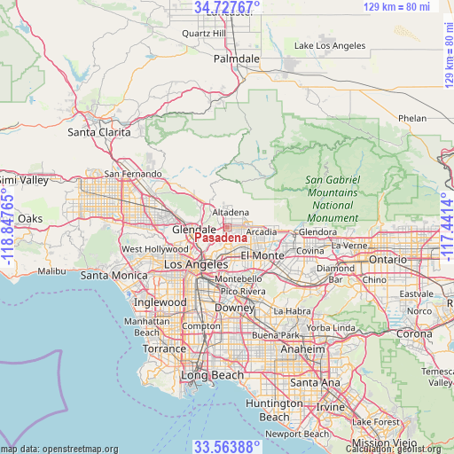
| Upper-left | 34.72767°, | -118.84765° |
| Center: | 34.14778°, | -118.14452° |
| Lower-right: | 33.56388°, | -117.4414° |
| Map W x H: | 129.4×129.4 km | = 80.4×80.4mi |
| max Lat: | 71.29058° ⇑79.3% North |
| Pasadena: | 34.14778° |
| min Lat: | ⇓20.7% South 19.06759° |
| min Long | Pasadena | max Long |
| -171.73463° | -118.14452° | -66.98998° |
| W 8.9%⇐ | ⇒91.1% E |
Elevation
Elevation of Pasadena is 272 m = 892 ft, and this is 22.8 m = 75 ft below average elevation for this country.
| Max E: |
3189 m = 10463 ft | 32.8% |
| Avg. | 294.8 m = 967 ft | |
| Pasadena | 272 m = 892 ft | |
Min E: |
-60 m = -197 ft | 67.2% |
See also: Pasadena elevation on elevation.city.
Geographical zone
Pasadena is located in North temperate zone (between Tropic of Cancer and the Arctic Circle). Distance of this Northern Tropic circle is 1191 km =740.1 mi to South.| Distance of | km | miles | from Pasadena |
|---|---|---|---|
| North Pole | 6210.2 | 3858.8 | to North |
| Arctic Circle | 3604.3 | 2239.6 | to North |
| Tropic Cancer | 1191 | 740.1 | to South |
| Equator | 3796.9 | 2359.3 | to South |


Nearby cities:
15 places around Pasadena: (largest is in red/bold)
• Alhambra
6.1 km =3.8 mi,  164°
164°
• Altadena
4.8 km =3 mi,  14°
14°
• Arcadia
10.1 km =6.3 mi,  95°
95°
• East Pasadena
6.6 km =4.1 mi, 99°
• East San Gabriel
7.9 km =4.9 mi,  141°
141°
• Glendale
10.2 km =6.3 mi,  266°
266°
• La Cañada Flintridge
7 km =4.3 mi,  325°
325°
• Monterey Park
9.7 km =6 mi,  168°
168°
• Rosemead
10 km =6.2 mi, 138°
• San Gabriel
6.8 km =4.2 mi,  148°
148°
• San Marino
4.6 km =2.9 mi,  129°
129°
• Sierra Madre
8.6 km =5.3 mi,  79°
79°
• South Pasadena
3.6 km =2.2 mi,  188°
188°
• South San Gabriel
11.9 km =7.4 mi, 157°
• Temple City
9.2 km =5.7 mi,  119°
119°
Sources, notices
• [Note1] Compared only with cities in United States existing in our database
• [Src1] Map data: © OpenStreetMap contributors (CC-BY-SA)
• [Src2] Other city data from geonames.org with taken over terms of usage.
• [Src3] Geographical zone / Annual Mean Temperature by Robert A. Rohde @ Wikipedia
