Rosemead geodata
Rosemead (California) is a populated place; located in United States in America/Los_Angeles (GMT-7) time zone. With population of 54,908 people, there are 842 cities with bigger population in this country. Compared to other cities in United States, 79.7% of cities are located further ↑North; 91% of cities are located further →East and 70.8% of cities have higher elevation than Rosemead. Note1


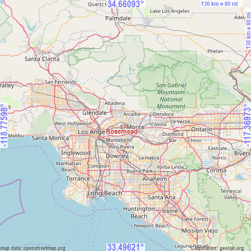
Rosemead GPS coordinates[2]
34° 4' 50.052" North, 118° 4' 22.26" West
| Map corner | latitude | longitude |
|---|---|---|
| Upper-left | 34.66093°, | -118.77598° |
| Center: | 34.08057°, | -118.07285° |
| Lower-right: | 33.49621°, | -117.36973° |
| Map W x H: | 129.5×129.5 km | = 80.5×80.5mi |
| max Lat: | 71.29058° ⇑79.7% North |
| Rosemead: | 34.08057° |
| min Lat: | ⇓20.3% South 19.06759° |
| min Long | Rosemead | max Long |
| -171.73463° | -118.07285° | -66.98998° |
| W 9%⇐ | ⇒91% E |
Elevation
Elevation of Rosemead is 96 m = 315 ft, and this is 198.8 m = 652 ft below average elevation for this country.
| Max E: |
3189 m = 10463 ft | 70.8% |
| Avg. | 294.8 m = 967 ft | |
| Rosemead | 96 m = 315 ft | |
Min E: |
-60 m = -197 ft | 29.2% |
See also: Rosemead elevation on elevation.city.
Geographical zone
Rosemead is located in North temperate zone (between Tropic of Cancer and the Arctic Circle). Distance of this Northern Tropic circle is 1183.5 km =735.4 mi to South.| Distance of | km | miles | from Rosemead |
|---|---|---|---|
| North Pole | 6217.7 | 3863.5 | to North |
| Arctic Circle | 3611.8 | 2244.3 | to North |
| Tropic Cancer | 1183.5 | 735.4 | to South |
| Equator | 3789.4 | 2354.6 | to South |


Nearby cities:
15 places around Rosemead: (largest is in red/bold)
• Alhambra
5.2 km =3.2 mi,  288°
288°
• Arcadia
7.4 km =4.6 mi,  27°
27°
• East Pasadena
6.4 km =4 mi,  359°
359°
• East San Gabriel
2.1 km =1.3 mi,  306°
306°
• El Monte
4.4 km =2.7 mi,  107°
107°
• Mayflower Village
7 km =4.3 mi,  56°
56°
• Montebello
8.5 km =5.3 mi,  200°
200°
• Monterey Park
5 km =3.1 mi,  246°
246°
• North El Monte
5.1 km =3.2 mi, 61°
• San Gabriel
3.5 km =2.2 mi,  299°
299°
• San Marino
5.5 km =3.4 mi,  325°
325°
• South El Monte
4 km =2.5 mi,  142°
142°
• South Pasadena
8.2 km =5.1 mi, 298°
• South San Gabriel
4 km =2.5 mi,  209°
209°
• Temple City
3.3 km =2.1 mi,  24°
24°
Sources, notices
• [Note1] Compared only with cities in United States existing in our database
• [Src1] Map data: © OpenStreetMap contributors (CC-BY-SA)
• [Src2] Other city data from geonames.org with taken over terms of usage.
• [Src3] Geographical zone / Annual Mean Temperature by Robert A. Rohde @ Wikipedia
