Alameda geodata
Alameda (California) is a populated place; located in United States in America/Los_Angeles (GMT-7) time zone. With population of 78,630 people, there are 505 cities with bigger population in this country. Compared to other cities in United States, 62.9% of cities are located further ↑North; 95.8% of cities are located further →East and 92.1% of cities have higher elevation than Alameda. Note1


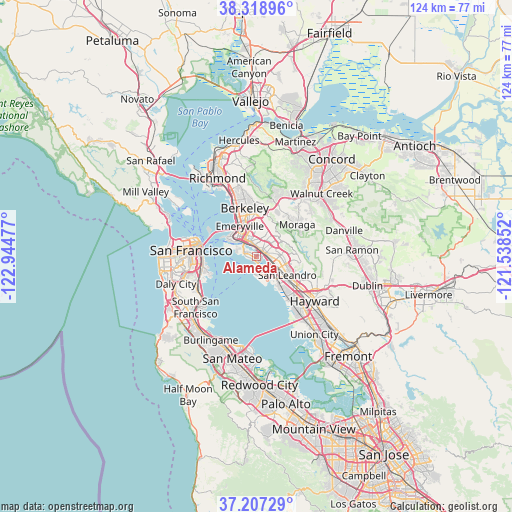
Alameda GPS coordinates[2]
37° 45' 54.756" North, 122° 14' 29.904" West
| Map corner | latitude | longitude |
|---|---|---|
| Upper-left | 38.31896°, | -122.94477° |
| Center: | 37.76521°, | -122.24164° |
| Lower-right: | 37.20729°, | -121.53852° |
| Map W x H: | 123.6×123.6 km | = 76.8×76.8mi |
| max Lat: | 71.29058° ⇑62.9% North |
| Alameda: | 37.76521° |
| min Lat: | ⇓37.1% South 19.06759° |
| min Long | Alameda | max Long |
| -171.73463° | -122.24164° | -66.98998° |
| W 4.2%⇐ | ⇒95.8% E |
Elevation
Elevation of Alameda is 12 m = 39 ft, and this is 282.8 m = 928 ft below average elevation for this country.
| Max E: |
3189 m = 10463 ft | 92.1% |
| Avg. | 294.8 m = 967 ft | |
| Alameda | 12 m = 39 ft | |
Min E: |
-60 m = -197 ft | 7.9% |
See also: Alameda elevation on elevation.city.
Geographical zone
Alameda is located in North temperate zone (between Tropic of Cancer and the Arctic Circle). Distance of this Northern Tropic circle is 1593.2 km =990 mi to South.| Distance of | km | miles | from Alameda |
|---|---|---|---|
| North Pole | 5808 | 3608.9 | to North |
| Arctic Circle | 3202.1 | 1989.7 | to North |
| Tropic Cancer | 1593.2 | 990 | to South |
| Equator | 4199.1 | 2609.2 | to South |


Nearby cities:
15 places around Alameda: (largest is in red/bold)
• Albany
14.4 km =8.9 mi,  339°
339°
• Ashland
13.7 km =8.5 mi,  124°
124°
• Berkeley
12.1 km =7.5 mi,  346°
346°
• Cherryland
15.5 km =9.6 mi,  128°
128°
• Chinatown
15.1 km =9.4 mi,  283°
283°
• Emeryville
8.3 km =5.2 mi,  332°
332°
• Mission District
15.6 km =9.7 mi,  267°
267°
• Moraga
12.5 km =7.8 mi,  51°
51°
• Oakland
5.1 km =3.2 mi, 329°
• Orinda
13.6 km =8.5 mi,  23°
23°
• Piedmont
6.6 km =4.1 mi,  7°
7°
• San Francisco
15.7 km =9.8 mi, 273°
• San Leandro
8.8 km =5.5 mi, 120°
• San Lorenzo
13.9 km =8.6 mi, 132°
• Visitacion Valley
15.3 km =9.5 mi,  249°
249°
Sources, notices
• [Note1] Compared only with cities in United States existing in our database
• [Src1] Map data: © OpenStreetMap contributors (CC-BY-SA)
• [Src2] Other city data from geonames.org with taken over terms of usage.
• [Src3] Geographical zone / Annual Mean Temperature by Robert A. Rohde @ Wikipedia
