Carnelian Bay geodata
Carnelian Bay (California) is a populated place; located in United States in America/Los_Angeles (GMT-7) time zone. With population of 524 people, there are 20579 cities with bigger population in this country. Compared to other cities in United States, 52.9% of cities are located further ↑North; 92.9% of cities are located further →East and 98.8% of cities have lower elevation than Carnelian Bay. Note1


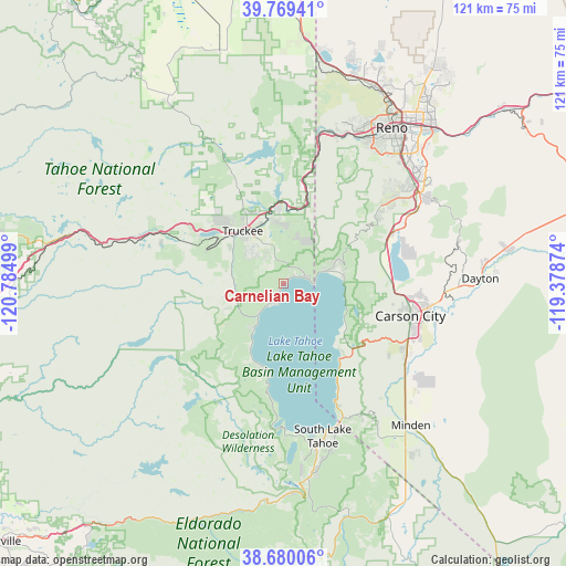
Carnelian Bay GPS coordinates[2]
39° 13' 36.66" North, 120° 4' 54.696" West
| Map corner | latitude | longitude |
|---|---|---|
| Upper-left | 39.76941°, | -120.78499° |
| Center: | 39.22685°, | -120.08186° |
| Lower-right: | 38.68006°, | -119.37874° |
| Map W x H: | 121.1×121.1 km | = 75.2×75.2mi |
| max Lat: | 71.29058° ⇑52.9% North |
| Carnelian Bay: | 39.22685° |
| min Lat: | ⇓47.1% South 19.06759° |
| min Long | Carnelian Bay | max Long |
| -171.73463° | -120.08186° | -66.98998° |
| W 7.1%⇐ | ⇒92.9% E |
Elevation
Elevation of Carnelian Bay is 1902 m = 6240 ft, and this is 1607.2 m = 5273 ft above average elevation for this country.
| Max E: |
3189 m = 10463 ft | 1.2% |
| Carnelian Bay | 1902 m 6240 ft | |
| Avg. | 294.8 m = 967 ft | |
Min E: |
-60 m = -197 ft | 98.8% |
See also: United States elevation on elevation.city.
Geographical zone
Carnelian Bay is located in North temperate zone (between Tropic of Cancer and the Arctic Circle). Distance of this Northern Tropic circle is 1755.7 km =1090.9 mi to South.| Distance of | km | miles | from Carnelian Bay |
|---|---|---|---|
| North Pole | 5645.4 | 3507.9 | to North |
| Arctic Circle | 3039.6 | 1888.7 | to North |
| Tropic Cancer | 1755.7 | 1090.9 | to South |
| Equator | 4361.6 | 2710.2 | to South |


Nearby cities:
15 places around Carnelian Bay: (largest is in red/bold)
• Carson City
28 km =17.4 mi,  104°
104°
• Dollar Point
4.6 km =2.9 mi,  199°
199°
• Genoa
32 km =19.9 mi,  140°
140°
• Incline Village
9.8 km =6.1 mi,  73°
73°
• Indian Hills
30.1 km =18.7 mi,  121°
121°
• Kings Beach
4.9 km =3 mi,  75°
75°
• Kingsbury
31.6 km =19.6 mi,  151°
151°
• South Lake Tahoe
33.7 km =20.9 mi,  165°
165°
• Stateline
31.9 km =19.8 mi,  157°
157°
• Sunnyside-Tahoe City
10.9 km =6.8 mi,  218°
218°
• Tahoe Vista
3 km =1.9 mi,  61°
61°
• Tahoma
18.2 km =11.3 mi,  192°
192°
• Truckee
14.2 km =8.8 mi,  322°
322°
• Verdi
33.4 km =20.8 mi,  13°
13°
• Zephyr Cove
27.2 km =16.9 mi, 156°
Sources, notices
• [Note1] Compared only with cities in United States existing in our database
• [Src1] Map data: © OpenStreetMap contributors (CC-BY-SA)
• [Src2] Other city data from geonames.org with taken over terms of usage.
• [Src3] Geographical zone / Annual Mean Temperature by Robert A. Rohde @ Wikipedia
