Ceres geodata
Ceres (California) is a populated place; located in United States in America/Los_Angeles (GMT-7) time zone. With population of 47,963 people, there are 1001 cities with bigger population in this country. Compared to other cities in United States, 63.7% of cities are located further ↑North; 93.7% of cities are located further →East and 85.1% of cities have higher elevation than Ceres. Note1


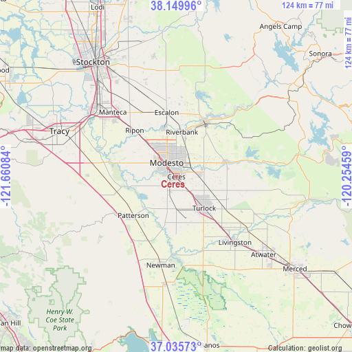
Ceres GPS coordinates[2]
37° 35' 41.748" North, 120° 57' 27.756" West
| Map corner | latitude | longitude |
|---|---|---|
| Upper-left | 38.14996°, | -121.66084° |
| Center: | 37.59493°, | -120.95771° |
| Lower-right: | 37.03573°, | -120.25459° |
| Map W x H: | 123.9×123.9 km | = 77×77mi |
| max Lat: | 71.29058° ⇑63.7% North |
| Ceres: | 37.59493° |
| min Lat: | ⇓36.3% South 19.06759° |
| min Long | Ceres | max Long |
| -171.73463° | -120.95771° | -66.98998° |
| W 6.3%⇐ | ⇒93.7% E |
Elevation
Elevation of Ceres is 28 m = 92 ft, and this is 266.8 m = 875 ft below average elevation for this country.
| Max E: |
3189 m = 10463 ft | 85.1% |
| Avg. | 294.8 m = 967 ft | |
| Ceres | 28 m = 92 ft | |
Min E: |
-60 m = -197 ft | 14.9% |
See also: Ceres elevation on elevation.city.
Geographical zone
Ceres is located in North temperate zone (between Tropic of Cancer and the Arctic Circle). Distance of this Northern Tropic circle is 1574.2 km =978.2 mi to South.| Distance of | km | miles | from Ceres |
|---|---|---|---|
| North Pole | 5826.9 | 3620.7 | to North |
| Arctic Circle | 3221 | 2001.4 | to North |
| Tropic Cancer | 1574.2 | 978.2 | to South |
| Equator | 4180.2 | 2597.5 | to South |


Nearby cities:
15 places around Ceres: (largest is in red/bold)
• Bret Harte
4.3 km =2.7 mi,  280°
280°
• Bystrom
3.8 km =2.4 mi,  319°
319°
• Del Rio
17.2 km =10.7 mi,  343°
343°
• Denair
16.1 km =10 mi,  118°
118°
• Empire
6.9 km =4.3 mi,  45°
45°
• Hughson
8.1 km =5 mi,  88°
88°
• Keyes
5.7 km =3.5 mi,  138°
138°
• Modesto
6 km =3.7 mi, 324°
• Riverbank
15.8 km =9.8 mi,  7°
7°
• Riverdale Park
8.4 km =5.2 mi, 280°
• Salida
16.7 km =10.4 mi, 317°
• Shackelford
3.7 km =2.3 mi,  304°
304°
• Turlock
14.8 km =9.2 mi, 138°
• Waterford
18.1 km =11.2 mi,  73°
73°
• West Modesto
7.6 km =4.7 mi,  289°
289°
Sources, notices
• [Note1] Compared only with cities in United States existing in our database
• [Src1] Map data: © OpenStreetMap contributors (CC-BY-SA)
• [Src2] Other city data from geonames.org with taken over terms of usage.
• [Src3] Geographical zone / Annual Mean Temperature by Robert A. Rohde @ Wikipedia
